
Over the summer TAG set out to answer a few burning questions:
- How much casual recreational access space (on MOD land) we have on our doorsteps?
- Where are the informal tracks and trails?
- How far do they extend?
- To what extent do footpaths and bridleways cover the military lands?
Just like the recreational user survey Byelaws Review did in 2020, when the results revealed a minimum of 59,000 hours of recreation per week just from those who bothered to complete the survey, the answers blew TAG away.
The short answers to the questions above could be summarised as massive, everywhere, a huge distance, and not much.
The longer answers, those that actually measure and quantify with some accuracy exactly what we enjoy and is up for review, reveals far more.
“My Lords, you will recollect that last Session I ventured to raise the question of the Surrey commons which the War Office was at that date anxious to acquire and about which there was a great deal of public anxiety both in Surrey and in London.”
Earl Russell – Hansard 22nd February 1928
Working out what our communities have and enjoy today has drawn on a variety of sources including Ordnance Survey supplied data files, open national and local government data, FOI responses, Strava stats, individually gathered GPS data and local knowledge. Its been brought together in professional geospatial mapping software. TAG won’t claim absolute accuracy but the answers are close enough to stand by. Having said that if anyone notices an error then please let us know as corrections, amendments or additions are welcome. TAG see this as a living, breathing and ongoing project.
The Ordnance Survey data arrived after TAG sought answers to explain why the areas around Bordon have lost their “Managed Access” markings on the map. The reason(s) for removal remain a mystery for now.
Love it or hate it, Strava has provided a wealth of visual information and revealing in some detail exactly where the community use the lands for walking, cycling or jogging. TAG are looking to use this data further but for now we rely on the heat maps.
If you want to skip the analysis and jump straight to the numbers then its all here:
TAG have created some PDF maps showing the areas, the trails identified so far, and the off-road feeder and link routes:
“The public shall have free access to the commons in accordance with their legal rights, and free access, subject to appropriate regulations, to the unenclosed lands adjoining the commons which are acquired or are being acquired by the War Department.”
Lord Onslow Under-Secretary of State for War – Hansard 22nd February 1928
Statistics are important but numbers alone don’t tell the whole story.
So just how much, where and what do we have today under the current byelaws?
How much casual access potential is out there?
Lots of Space – How Much?
“Space is big. You just won’t believe how vastly, hugely, mind-bogglingly big it is. I mean, you may think it’s a long way down the road to the chemist’s, but that’s just peanuts to space.”
Douglas Adams
TAG reckon there are approximately 15,300 acres of open space available on the military lands for casual recreation when not in use by the army.
That’s 5 times the size of Heathrow Airport (3032 acres) with the added bonus of being far less noisy and busy. Swinley Forest, home of the blue and red route formal mountain bike trails, is not even close at a mere 2,600 acres and most of which remains (officially) off-limits to bikes.
Put simply, there is a lot of open MOD space and its neatly distributed to give everyone a convenient spot of wild nature within a short walk or bike ride.
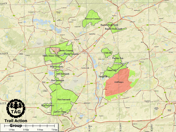
Here’s a map showing the areas covered by the Aldershot and District Military Beylaws and for completeness Hankley Common. Hankley does not come under the Aldershot byelaws but nevertheless it maintains casual access and is local.

As we will see the cluster of open access lands is critical for the longer distance off-road rides. Here’s a closer look at the Aldershot area:
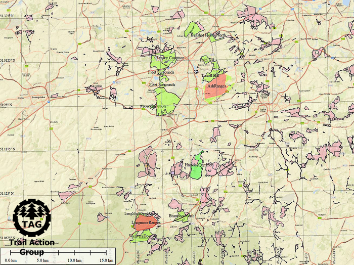
The lands to the south are not so extensive but still important:

Two areas fall inside the South Downs National Park; Longmoor and Weavers Down:

There is a legal framework in which certain areas of land are designated to permit casual access. It is called the Countryside and Rights of Way Act 2000 (aka CROW). In areas designated under the Act the public is granted a right to roam – something very closely aligned with Section 2 of the Aldershot Byelaws – but there are some issues:
- The designated areas are typically small and fragmented
- At 12,788 acres they are less than the area of local MOD lands
- They are poorly located to serve the majority of the community
This map highlights the issue. Green and red areas are MOD casual access and pink areas are designated CROW:
The quality of open space is also worth questioning; one of the CROW areas is Hankley Golf Club course. Try wandering around that space and a few things become apparent; golf balls are hazardous and golfers object to their play being disturbed, and with neatly clipped grass the wild experience is a bit lacking. The golfers have paid for their membership – disturbing their play isn’t really going to help community relations.
However, the bigger problem is location. The major centres of community – Aldershot, Fleet, Farnborough, Camberley and surrounds – are poorly served by CROW yet the sparsely populated area around Frensham and Alice Holt are richly served. The supply isn’t where the demand is.
Do we all want to get into the car and drive to get our wild open space fix? What would the loss of casual access to the MOD lands look like if CROW was the only alternative?
These are questions worth asking and seeking political answers to ahead of the much delayed byelaw review and certainly way before fear-based messaging and locked gates on MOD land becomes normalised and deemed acceptable by the local community.
And let’s be clear; putting up fencing, locking gates and putting up danger signs on a mostly empty piece of land isn’t a prime example of normal behaviour, is it? And there are always better ways to educate than using fear based imagery devoid of supporting evidence.
Rights Of Way
After establishing how much space we have access to TAG then asked how far? How do the lands link up? Where do existing rights of way run and how do long distance routes join in?
The first check was a look at where the bridleways and foot paths – the rights-of-way – run. Using the mapping tool we can hide the map layer to highlight and visualise the question:

Zoomed in to each area we can take a closer look:

Measuring exactly how much rights-of-way exist on MOD land revealed:
| Area | Right-of-Way (Miles) |
Long Valley/Velmead/Caesars Camp | 0 |
Fleet Pond/Norris Hill/Minley South | 1.81 |
Minley Manor | 1.37 |
Hawley Common | 6.39 |
Barrossa Common | 2.38 |
Bagshot Heath North and South | 1.48 |
Porridge Pots and Frith Hill | 0.98 |
Tunnel Hill | 1.25 |
Ash Ranges | 5.26 |
Hankley Common | 7.85 |
Bramshot | 5.08 |
Longmoor | 3.79 |
Weavers Down | 0 |
| Total | 37.65 |
We have not broken the analysis down further and split bridleways (foot, bike and horse) from footpaths (foot only) but do not expect much better than 50% to be legally usable by bike or pony. Nor does it factor in that there are no restraints on where you can walk.
Which sounds like quite a lot, right? As we will see the short answer is no, not at all.
“Please be assured that the MOD fully understands how essential it is for local communities to have access to open land to carry out recreational and leisure activities, and the Department remains committed to fostering positive relationships with our neighbours.”
The Rt Hon Tobias Ellwood MP – Parliamentary Under-Secretary of State and Minister for Defence Peoples and Veterans – letter to constituent November 2017
With the exception of Hankley Common none of the rights of way really go anywhere useful. Thats not to say they are unused for just for a cycle or walk but it’s all a bit linear and that’s not how folks use the lands, and all require the use of a long distance trail or road to gain access.
Some of the larger areas such as Velmead, Long Valley and Caesars Camp, have no right of way whatsoever and recreation is 100% dependent on Section 2 – casual recreational access when not in use for military training – to enable the space.
Nor are they in the right place. The distribution again favours the lesser populated parts of the counties and isn’t clustered around where they are needed.
There is however some good news. Off-road feeder and link routes exist:

The MOD lands are linked by an extensive and mostly off-road set of permissive or right-of-way routes:
- Sustrans – National Cycling Network
- Cycling UK – King Alfred’s Way
- Basingstoke Canal
- Blackwater Valley Path
- Shipwrights Way
- Greensands Way
All enable safe off-road routes into and through some of some truly stunning, wild countryside and most of that is MOD land. Cycling UK’s King Alfred’s Way is notable and creditworthy as it helped establish a very short (approx 1km) but significant length of permissive path through Caesars Camp/Beacon Hill joining up two bridleways that otherwise required a diversion along busy A roads.
Miles and Miles of Lovely Trails
The next step was to figure out how we all use the lands. Riding the routes and gathering GPS was a sheer pleasure but Strava provided a rich source of where we walk, run and ride.
“I can however assure you that officials have been directed to ensure that existing gates are open for public access to Long Valley when it’s not in use for military training.”
Jeremy Quin MP – Secretary of State for Defence Procurement – letter to constituent July 2019
It was clear from early on the distance was going to be massive. And so it proved with the latest count of 414.4 miles of informal tracks, trails and routes though the MOD lands.
This included rights of way and literally everything else. Yes, it really is 414.4 miles and here’s a breakdown:
| Area | Tracks and Trails (Miles) |
Long Valley/Velmead/Caesars Camp | 84.26 |
Fleet Pond/Norris Hill/Minley South | 11.75 |
Minley Manor | 18.35 |
Hawley Common | 31.9 |
Barrossa Common | 21.89 |
Bagshot Heath North and South | 12.04 |
Porridge Pots and Frith Hill | 27.73 |
Tunnel Hill | 21.85 |
Ash Ranges | 66.66 |
Hankley Common | 38.52 |
Bramshot | 8.18 |
Longmoor | 30.65 |
Weavers Down | 31.05 |
| Total | 414.4 |
We are not sure if we got ’em all but are confident the total distance is at least 414.4 miles.
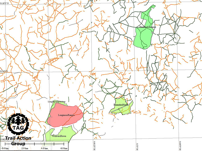
The maps reveal the true extent:

The decision was taken to include the currently closed part of Ash Ranges. All the evidence suggests its still very much in use in spite of its recent closure.

TAG understand there is some enthusiasm for permissive and linear routes. To put it bluntly there is no appetite or desire to see a concession that compels riders and walkers to stick to a designated path or route. To think behaviour will change with a few signs is likely to end in wasted money, disappointment and alienating the locals. Attempting to measure every transgression off a designated track in the Aldershot area as an incursion will be impossible and won’t create or maintain positive community relations.
Measured and Valued – At Risk
So now we know, or at least have a very good idea of what is at stake. The area open for casual recreational access is massive and the distances open to ride, walk or jog are mind boggling.
And the risks?
Regrettably Long Valley has provided a view of what might happen in the future with putting in fences and locked gates open for high days and holidays. It also draws into sharp focus what happens when politicians engage and set out how things will be. Each incumbent Secretary of State says one thing and the reality served up on the ground is something unrecognisable.
“Additionally, I have been told its the MOD’s intention to include foot gates at various access points and work has been commissioned to address this issue…”
Ranil Jayawardena MP – letter to constituent dated April 2021
A reasonable summary would conclude that the reality of access has fallen very far short of the expectations set.
Politicians and MOD alike patiently explain and recognise the need to maintain these spaces for recreation when not in use – and the government publishes guidelines for healthy lifestyle and policy setters to follow. But the gulf between the stated political assurances to maintain recreational access when not in use and the reality of locked gates and barbed wire topped deterrent fences is more of a Grand Canyon sized chasm than a gap.
TAG could go on and provide more political statements but repetition gets tiring. Eroded trust marks them all down as well-meaning-but-useless. Adding more just burns meaningless words into irrelevant pixels on the screen.
Reinforced by the access issues at Long Valley and Deepcut and loss of 340 acres at Ash Ranges, the deep concerns with the pending byelaws review has been and will remain twofold:
- Loss of Section 2 and casual recreational access when not in use
- Loss of access via more fencing and locked gates in other areas
Miracles aside there is no alternative space available and certainly not in the crowded urban regions. The MOD area is extensive and for those who like to ramble on foot, by horse or bike the choice of routes is as close to infinite. No one ever need ride the same route twice in a decade, perhaps a life time if they choose. Fancy an off road ride from Yateley to Weavers Down? A 60 mile off-road ride is there for the taking and there is plenty of choice for the route even if the army are using part of the lands for military training.
What we have is priceless. We humans are part of nature and we are meant to be right there in the wild. The value is immeasurable and whilst the statistics of 15,000 acres and 59,000 hours of use a week are almost mind blowingly high the benefit to the locals in the form of mental and physical health to wider society should firmly and robustly outweigh and silence dissenters.
The lands must remain open for casual access. The normalisation and acceptance of locked gates and barbed wire cannot be permitted or left unchallenged.
The physical and mental health of our local community is depending on it.

Pingback: Did You Know – Doing It Right? | Trail Action Group
Pingback: MTB And Erosion – How Much? | Trail Action Group
Pingback: Did You Know – Where Are They Hiding? | Trail Action Group
Pingback: Did You Know – Bird Benefits | Trail Action Group