DIO Public Safety Announcement; Single Track Is Dangerous (Spoiler Alert: No It Isn’t)

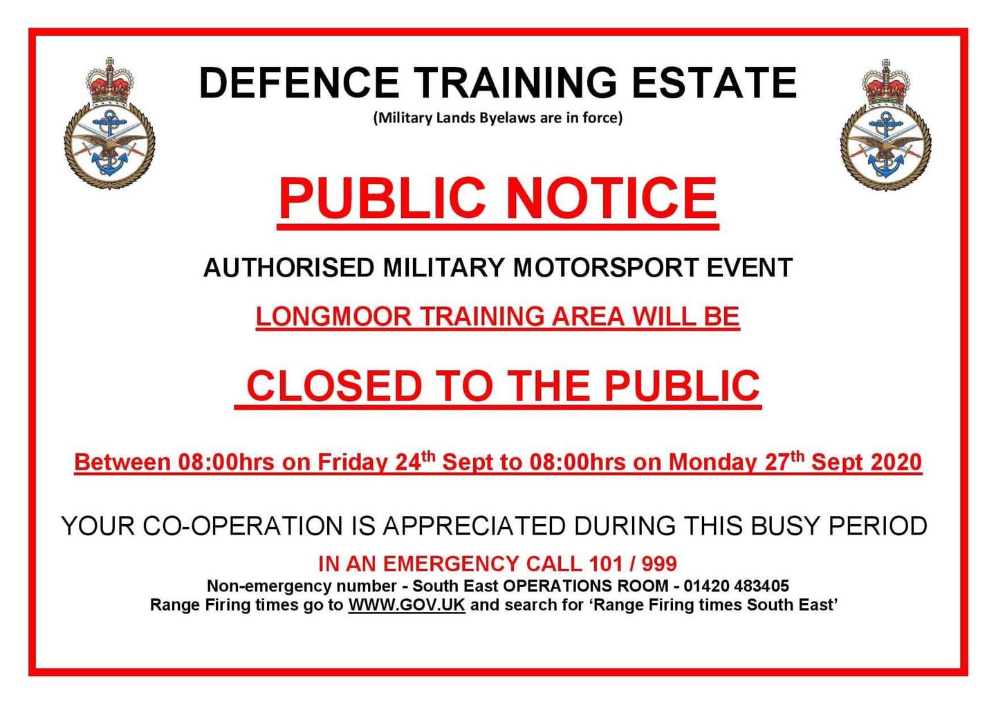
3rd April 2024 – Update. TAG have gathered more evidence to demonstrate how DIO’s ideas around safety are misplaced. Section added below.

Whenever we hear DIO pass comment on matters related to MTB and cycling, it’s difficult to see a connection between the abstract ideas, and the reality. The basic theory is fine but the nuanced detail and most importantly, hard facts and real insight, are absent.

If you are a regular reader of the TAG blogs and don’t need to watch a series of videos picking DIO’s “policy” apart, feel free to scroll to the end and write to your MP asking them to start pressing the case for DIO to stop treating cyclists with contempt, recognise the reality of how we use the lands and to treat cyclists with respect.

If not, do please read on.

Faced with new byelaws* DIO will need to be seen to do something to accommodate cyclists. So far the mood music TAG has picked up on suggests cycling on some fire/vehicle roads will be permitted, but the single track we use and love will be strictly off-limits.

How a legal definition is going to read and be interpreted will be very interesting. But it will be even more entertaining to sit back and watch DIO actually try enforce the unenforceable.

The experience driving around the fire roads in a pickup cannot be considered the same as riding a bike along the 400 miles or so of informal routes.

Why is single track off limits? Apparently it’s not suitable because the speeds cyclists can reach are dangerous.

Yes, according to DIO single track is inherently more dangerous than a fire road so we must never use them for the safety of all. Even if no one else is there.

There are risks and costs to action. But they are far less than the long range risks of comfortable inaction.

John. F. Kennedy

TAG have a few observations on this mindset.

Firstly, we must suspend the reality of vehicles are using the fire roads because, obviously, there is some magic force field that prevents cyclists ever coming close to one.

TAG would like to see the risk assessment for this one. How do cyclists and vehicles avoid each other if they are compelled to share the space? The evidence base to support this policy would be appreciated as well.

Then we must also forget that sometimes single track goes uphill.

Some of if doesn’t and gravity is a great asset, but DIO are ignoring the simple laws of physics here. Some objective evidence would be required (Civil Service contract of employment and Standards in Public Life) for us to be convinced, but TAG concludes the evidence won’t exist. Or DIO have deleted it for “business purposes”.

If DIO can ignore ministers, then ignoring the laws of physics is simple. Hands up who can cycle uphill at 20mph? Anyone?

Next we must ignore the flat bits. With the heart rate running close to 180bpm a pace close to 10 mph is a good effort on a dry day. Just check the Strava stats of a few of the single track segments. Then try sustaining that level for a full ride. Anyone who can hold that pace should be in the olympics or racing professionally and at this point we are deep into edge cases. Most mere mortals want a nice day out and that includes a bit of single track.

And last but not least we need to suspend reality and forget there are fire roads that end in a dead end with tracks leading off in all directions. Or terminate in a locked gate.

None of it makes any sense or reason, but just as the locking of gates on a vacant Long Valley has taught TAG…never, ever expect logic or good reason to apply when DIO set their hearts on achieving a bonkers agenda.

He who is not courageous enough to take risks will accomplish nothing in life.

Muhammad Ali

If DIO would like to get in touch and share evidence, then please use info@trailactiongroup.co.uk to drop us a line.

It’s also galling to watch other user groups, typically organised events, runners, orienteering groups or the Pony Club, seeing no such restrictions. The drag hunt didn’t stick to the fire roads…why should we?

Hypocrisy? Double standards? Bias and prejudice? TAG certainly think so. But before we seek some help with accountability, lets have a look at some evidence.

A Beginners Guide to Single Track Use

As part of our service and in spirit (if not in practice) of postive collaboration and cooperation, we have pulled together some short explainer videos. These will give DIO staff a deeper insight into how MTB use the lands, and what measured speeds we can actually achieve when using single track.

Is this data perfect? No, not at all. But its a lot better than nothing, or basing policy on thoughts and feelings.

But first we need to highlight a DIO spoiler alert; MTB is not as fast as you want to think it is.

First up, a short video on what DIO may think is acceptable and safe to use a bicycle:

Just like sticking to the fire roads, watching a video is dull as dishwater and unnecessary. So we won’t be wasting too much time and keep the video short. Just enought to bore the viewer into getting why fire roads are not where the pleasure really is.

Next up, some single track with a spot of downhill:

We are not saying speeds can peak, but to set policy that all single track is dangerous when only part may (stress may) carry higher risk is neither rational or reasonable.

Nevertheless, that video is likely to give DIO kittens.

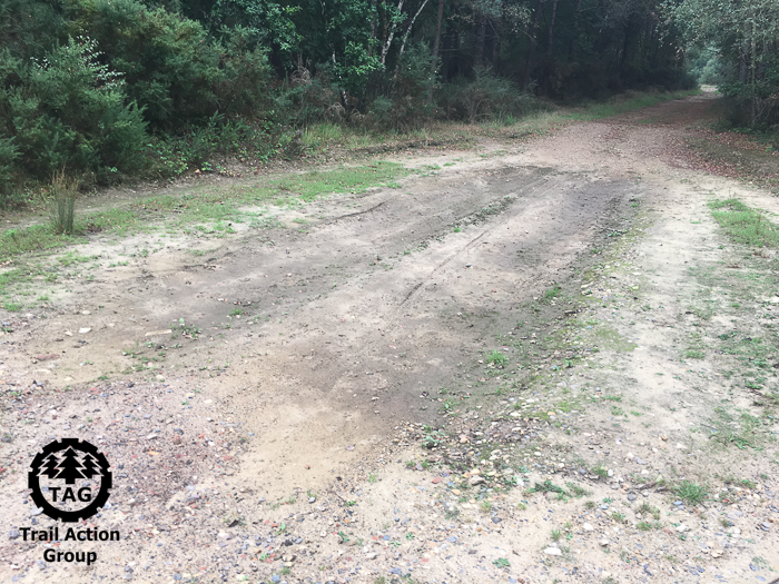
It’s got tree roots. And off camber slopes. And it’s downhill. Some sections have a rooty, camber and slope combo. Its loaded with more perceived risk than Russian roulette with 5 live chambers…but feel free to fast forward to the end and see every MTB rider arrive alive and well at the next fire road.

Next up we have a little track that runs downhill, but again the speeds are kept low by the nature of the trail and terrain. It twists and carries natural features that slow riders:

Check the speed. It’s all single track and some downhill but there is a good line of sight.

Plenty of natural, twisting track here to keep a downhill speed low.

Risks where speeds can be higher can be mitigated by design. But this would need a) DIO to accept cycling was welcomed and b) cooperation with folks like TAG who understand more about than MTB that someone who drives around the lands in a pickup or sits behind a desk. This should be something your MP can help with and by writing to them (read on) it helps press for DIO to change.

Now we have a section of single track/multi-use in a part of the Aldershot lands where military training is not permitted thanks to the rules in the Aldershot Standing Orders:

Section of multi use track that DIO maintain is not safe for cyclists. Even if it’s flat and no troops present. TAG have given up hoping DIO will apply logic to anything.

And here we have the classic dilemma DIO are unlikely to be able to reason away and another example of where DIO logic meets reality. And the “logic” falls over. The fire road ends and three single track routes carry on:

Are DIO really expecting us to just turn around because the fire road ends? When decades of use has established the trails? Honestly?

Here’s another great example. The fire road runs into a locked gate:

These gates block a long-standing access point. Local MP Ranil Jayawardena reassured residents some new gates were coming to Long Valley 3 years ago, but DIO have yet to deliver.

This section of single track is in Long Valley. It’s an undulating, twisting route and speeds are hardly peaking. The finish is uphill and it’s a short and steep one. Check out the heart rate at the end to see the effort expended:

The rider is 56 years old and has maintained fitness over the decades by riding on the lands. A heart rate peak of 193bpm is high for some but normal in this instance.

The best kind of single track is one that demands 100% concentration. Thinking about the ride and nothing else becomes so immersive the worries carried onto the lands slip away as both mind and body are exercised, reset and refreshed. The rider, whose heart rate peaked at 193bpm is 56 and remains fit thanks in part to these lands and trails.

The ethos and heart of the matter for MTB is living in the now and engaging mind, body and spirit with the ride and what is going on. In military speak it’s called situation awareness and this moment is not available to anyone stuck inside a pickup cab.

“I am always doing that which I cannot do, in order that I may learn how to do it.”

Pablo Picasso

This is why we ride single track. It goes to the core of what it is to be a cyclist and a mountain biker. DIO must realise and accept the fire roads are just not going to cut it.

If anyone knows of other completely bonkers examples of where fire roads terminate and leave the cyclists with nowhere to go, do please send us a location. Or better still, video it!

No prizes for the best example, but a really warm glow is assured knowing you are holding DIO to account for their policy and actions.

Updated section

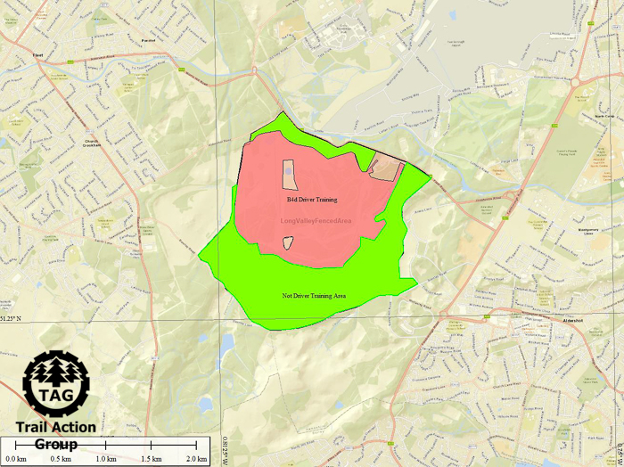
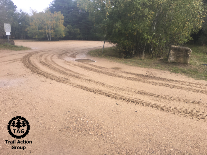
TAG have found a place where MTB can pick up the kind of speeds DIO find troubling. Just ride any downhill fire road and watch the pace climb as gravity takes over. Fire roads are where vehicles must be used. The Aldershot Standing Orders (Page 13, 37.d) says so and this narrow space is what DIO expect cyclists to share “for safety”.

Here’s a run down from the top of Caesars Camp:

DIO worry about speed. Yet the fire roads are where MTB can really pick up and maintain pace. TAG have given up expecting rational, evidence lead policy from DIO…picking apart their daft and emotive thinking is straightforward.

In all cases evidence must be used to set policy. The videos TAG produce count. So does the GPS data everyone gathers. Strava Heatmaps…open source or paid for detail…they are all robust evidence that informs what really goes on. We fully expect DIO to engage and seek to understand exactly what the real issues are, and we will listen to any valid and evidence-based concerns. We will alway seek cooperation and if necessary compromise.

But remember, as taxpayers we are paying for this “service” and TAG firmly believe DIO can and must go a lot further to make sure the local community receives value for every penny.

Some of the videos were shot in Long Valley on the single track (blue dashed line) and has avoided the DIO made up tracks (brown dashed) and uses just a little of the test track routes (not shown for clarity). A GPX file of the blue route is available.

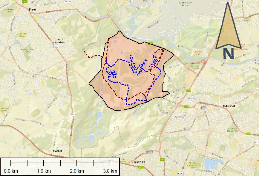
If any MTB rider wants to live right on the edge and check out the dangerous single track in Long Valley that featured in some of these videos, we have a GPX file that will guide. WordPress does not like us uploading these file types so just drop us an email to info@trailactiongroup.co.uk and we will send a copy.

Cyclists To Blame

TAG are firmly of the view that any permissive routes will be respected as much as Section 4.2 no cycling ban of the current byelaws. There is plenty of evidence to suggest cyclists have ignored the laws since 1976 when they first came out, and there is no indication this will change.

The outcome will continue to see recreational cyclists ignoring what amy daft law drafted out outlaw single track says, and what DIO think is a good idea. Its all unworkable.

Thus DIO will continue to blame (in their opinion) irresponsible cyclists for ignoring the laws, continue to treat the cycling section of society with a mix of prejudice, distain, contempt and arrogance. DIO will continue to use to blame MTB to excuse more fences and locked gates.

The mountain bikers are irresponsible and dangerous, and refuse to follow the law…so we have to block access for all. Mountain bikers will be a handy scapegoat.

It’s all our fault. Even if it isn’t.

But that will suit DIO’s broad agenda and hostility towards all recreational users. Except of course those who pay (carrying a firearm, riding a horse, killing animals, drag hunts, commercial dog walkers…the right sort) or those considered favourable (Ramblers, equestrians) even if their numbers are dwarfed by cyclists.

Never let the facts get in the way of egocentric policy. Based on current behaviour this is likely to be DIO’s reasoning and justification.

What Can You Do?

The truth is more likely DIO are unable or unwilling to accept casual access of any kind, but are unlikely to go up against the walkers or Ramblers. The former are vocal and numerous, and the latter legally prepared and have challenged DIO in the past. Instead they focus on what they think they can control and target what they see is a minority, even when there is zero evidence to suggest they actually need to do anything.

Waste of taxpayer money? TAG certainly believe so.

Any and all letters to the local MPs help raise and maintain the profile of how important recreational use is.

Write to your MP, asking that DIO be compelled to use a firm evidence base to set policy, and that cyclists be given equal status as what those on foot enjoy today. Remind MPs that DIO are ignoring ministers and ask why this is permissible and what do they intend to do about it?

Anything less will see DIO remain openly hostile to a section of society. 4200 people identified as cyclists in the byelaws recreational survey, so it’s hardly a minority view or an edge case pleading here is it?

If you would like to read or remind yourself of the survey, here’s the NE Hants constituency copy:

In this election year remind your MP your vote counts. If it’s true, tell them the lack of support for recreational access to the lands will lose your vote.

The easy way is to use the ever-helpful Write to Them website.

*Latest update on the byelaws. They are due to be published as a stream of radiation pulsing from the heart of our sun after it has consumed its fuel and collapsed under its own weight. Thats in roughly 6.4 billions years from now…but DIO are likely to consider this timeline achievable.

Deleted Evidence? Gather Your Own…

5th February 2024; Since we first published this blog more evidence and information has come to light. We have updated the blog accordingly.

TAG have been consistently raising concerns over the abuse of the DANGER signs at Long Valley. Since their implementation combined with installing fencing and use for the 2018 Farnborough Air Show (which apparently lasted 2 months) the desire to exclude recreational access at all times irrespective of use or risk has been endemic. Just in case anyone was wondering the Air Show is a civilian event (not military training) and did not require all 950 acres at all times. But that’s what DIO’s DANGER signs claimed.

DIO notice stuck to the fence. Note “MOD will support access when not in use”. Its regrettable DIO do not honour this commitment.

But before we dig deeper into the failings let remind ourselves what DIO used to justify the fence and £250k spend. Hung on the fence are laminated signs setting out DIO justification.

The DANGER signs assert military training is underway and poses risks greater than the regular dry training conducted on the rest of the open estate. To be telling the truth both conditions need to be true.

But as TAG have demonstrated back in 2020, 119 hours of use from a total of 2200 hours of locked access cannot be described as balanced or rational.

Nor can it fit the direct instruction from the Minister of State for Defence Procurement, Jeremy Quin MP.

In July 2019 the Minister assured residents:

“I can however assure you that officials have been directed to ensure that existing gates are open for public access to Long Valley when it’s not in use for military training.”

JEREMY QUIN MP – SECRETARY OF STATE FOR DEFENCE PROCUREMENT – LETTER TO CONSTITUENT JULY 2019.

That’s DIO’s political boss making it really, really clear. Except DIO have clearly not got the memo. Or are unwilling or unable to implement it. Or treat Ministers with contempt.

Neither the local politicians or the Junior Minister picked up on the simple fact DIO staff are ignoring them.

Deleted Records? Make Your Own

Not long after TAG started analysing the booking on and off records DIO started deleting them within 48 hours.

The “no good business reason” justification was given but TAG take the view DIO are deleting stuff that is so inconvenient and directly challenging the “always in use” excuse to keep people out. Sharing this stuff just does not fit their narrative or desire to exclude recreation.

The fact is, there is a thing called the Seven Principles of Public Life and these are supposed to guide civil servants and their behaviour.

1.3 Objectivity clearly says “...using the best evidence and without discrimination or bias.

TAG firmly believe the local community is not being served here. Cyclists remain discriminated against while simultaneously other groups are welcomed with a dedicated contact or charged a fee and free to carry on. Gates remain locked for days at a time when the evidence is clear and nothing – certainly not dangerous training – is happening.

Standards do not say “delete anything inconvenient”. TAG firmly believes the in-use records will exist and are held elsewhere but DIO would rather not share them publicly for scrutiny.

In the meantime DIO expect the local community to serve up obedience to signs that are not communicating a valid and truthful message.

So TAG set out to gather their own set of evidence.

Visual Records

The soft, sandy soil of Long Valley is like an Etch-a-Sketch pad. The tracks and marks of anything left by a vehicle, dog walker, cyclist, deer or even a snake are quickly weathered.

Every day is a blank slate. By observing the changes and state of the tracks it becomes easy to take a very good estimation of what has – or has not – happened in the previous 24~72 hours.

And if you take a picture a permanent record is created. Smartphones will record not only the scene but the latitude & longitude and GPS derived time of where and when the image was created.

Distribution of photos recording what is or is not happening in Long Valley plus location of popular trails and routes. The patches in the driver training area are covered in this blog.

Which is exactly what TAG supporters have been doing, starting in 2018 and increasing after DIO announced booking on/off records were being quickly deleted.

TAG now have 750 950 1040 individual images creating a persistent record of when, what and where was going on in Long Valley.

Here’s a selection of what recent use looks like:

And here is a selection of what little or no use, or who used it last, looks like.

The sequence of tracks is important – cycle tracks over tyre makes show who and how many have used the area since a vehicle has passed through. Clear puddles show no recent vehicle movements and so speak for themselves.

Update: On quiet weeks where nothing moved, one vehicle would transit the area. Was this training? Or something else? TAG pondered this for a while and then the likely answer was found in the Aldershot Standing Orders.

Combat Service Support Training and Development Unit (CSS TDU) operates the test track and this:

...CSS TDU is to inspect the condition of the track and barriers at least once a week…

Which struggles to qualify as military training. The vehicle leaving the weekly tracks is staff simply inspecting the routes. It wont need 24/7 lockout to achieve this.

Sometimes the only evidence of vehicles moving around – mostly outside of the designated driver training areas – is the pickup carrying the person charged with locking the gates.

The red area (465 acres) is use for driver training. Standing Orders or physical restrictions (trees!) prevent the green area (461 acres) from use therefore the fence is in the wrong place, if indeed it’s ever been really needed. Vanity project? TAG are inclined to think so.

The clues of what has been going on can, with careful observation, be read.

How fresh are the tracks?

What has the weather been doing?

What tracks are present and in what order?

What is the vehicle tread type or walkers shoe pattern?

Are there dog tracks too?

How clear are the puddles?

How many weeds are growing in the test track?

It boils down to two primary indicators. Just like objectively measuring wear on MTB trails its the presence or absence of change that tells the story.

All of these are pointers that on their own don’t tell much. But together collectively build up a fuller picture.

The fence itself, whilst very unwelcome, makes it easier to monitor the space. Gates create natural pinch points that anyone and anything must pass through. Presence or absence of fresh tracks is a strong indicator as to how much the land is being used.

The short answer of how much use is “not much”. The status quo established in 2020/21 with just 119 hours from 2200 hours of locked gates remains broadly consistent today.

The Evidence

With such a rich set of evidence it’s difficult to share all of it in an easy to digest form. TAG are willing to consider any requests to review the evidence gathered and any interested party may request a copy by dropping an email to info@trailactiongroup.co.uk

The data about the images tells its own story. In the link below TAG have shared the list of images, latitude & longitude (WGS84 is the datum), and time/dates as an Excel spreadsheet:

Based on that list DIO should be able to correlate the times and dates to their own records. Providing evidence that demonstrates a) when training was underway and b) the training carried a risk profile higher than regular stuff that happens across the rest of the estate should be easy.

On this point TAG firmly welcome any and all evidence based challenge. And TAG will take a moment to remind everyone that civil servants are required to use the best evidence.

Equally, TAG will take silence from DIO as acquiescence and tacit confirmation Long Valley really is more empty than in use.

Or to put it another way “Because we said so” won’t pass the test.

TAG now believe DIO will seek to apply the same “When we say so” rules of access everywhere if they can get away with it. DIO staff are already on record stating new byelaws will contain closed and restricted areas and Long Valley access policy is very much the canary in the coal mine warning of a highly restrictive future if nothing is done.

February update: Long Valley has been closed for weeks and there has been little sign of use. All of this changed on Sunday 4th of February when the area saw plenty of activity. The local drag hunt were granted access, yet the gates were locked and the DANGER signs proclaimed military training.

Times are hard and budgets tight. Military training reverting to horses might save money on armoured vehicles and we know the Ajax program is over budget and late…But this more Pony Club than Light Brigade. Civilian events fail to meet the minimum test for closure of military training. DIO will permit recreation if it’s the right kind. Double standards? We certainly think so.

No one minds the local horse riders enjoying the space and we would welcome more equestrians. What remains deeply objectionable is DIO and their continued efforts to publish mendacious information, claim the area is dangerous and lock the public out. Asking the local community to believe false claims is simply not acceptable.

With Caesars Camp and Beacon Hill busy with military training – including blank firing – Long Valley remains empty and yet denied as an alternative for casual recreation. DIO are really pushing an agenda of conflict instead of working towards a positive outcome for all users – military and civvy alike.

Update: Drag hunt hoof marks (Sunday 4th 2024) on test track on top of single vehicle track from previous week. Photo taken Tuesday 6th 2024.

TAG, and indeed the wider community, would welcome an explaination from DIO here. We all deserve some help in understanding how recreational equestrian use on a vehicle test track remains compatible with signs that declare the area is being actively used for military training, and said training is dangerous.

Put it simply, if the rest of the estate sees Long Valley style restrictions we can all kiss goodbye casual recreational access when not in use (or when DIO say it is not in use – Easter and Christmas / New Year?). We will remain at the whim and ego of DIO senior management, who will unilaterally decide when access is appropriate and consider high days and holidays suffice for us mere proles.

The Outcome

The track record of DIO staff meeting direct Ministerial instructions (Jeremy Quin) and MOD policy for access when not in use is abysmal. One immediate outcome should see gates unlocked when not in use.

Even when on their own website they state the land is open after 16.30pm as published on the Gov website the signs do not reflect this.

Left unchecked DIO are, on balance, more likely to serve up more restrictions, more locked gates and more empty space irrespective of actual use. Its all a ratchet that clicks one way.

All statements to the contrary – from politicians and MoD – should be measured against the evidence and treated as false until proved by deeds and actions. The ratchet clicks. Access is lost. In less than a decade it’s gone.

Is that a future we want?

TAG think not.

That is why openly challenging and raising questions about the lack of recreational access at Long Valley is critically important.

Long Valley presented an alternative space when Caesars Camp was busy. By closing off 950 acres irrespective of use DIO are driving conflict. TAG would not be surprised to find DIO seeking to trigger more disruption and conflict between recreational users and the army, stuff that would in their eyes justify more restrictions and serve to strengthen the DIO desire to remove casual public access.

And this is why we are asking everyone to raise the matter with their local MP.

You do not need to be a user of Long Valley to raise these concerns, just be aware of the systemic risks posed by DIO to our recreational future.

If you are still not sure and think DIO are really nice chaps seeking harmony and cooperation with the community, just ask the residents of Ash (or indeed serving military personnel) how DIO treated them during the pandemic. If there is ever a guide book to be written on how to disengage and enrage an otherwise previously supportive community then DIO would be that author.

TAG have little faith in the political process and the local MPs. The evidence suggests DIO run rings around them and even Ranil Jayawardena MP seems unwilling to challenge DIO over a few simple extra gates that were promised.

But we do have an election coming and how DIO have treated our community is going to be a factor.

And finally, don’t believe any “…not intention of MOD to restrict access…” guff if and when an MP replies.

This is comfort jargon – handy soothing phrases intended to make us feel like everything is going to be fine but the reality is different. Government bodies like DIO and politicians are skilled at this form of communication but it’s quickly shredded as meaningless bullshit when checked against reality and measured against outcomes.

All the evidence and outcomes thus far directly and irrefutably demonstrates that DIO has every intention to restrict access, perhaps the early steps in a strategy to sell off the land for housing?

When deeds, actions and outcomes are measured, such words are seen to be meaningless soundbites and spin.

Lovely Weather – Fire Risk

The nature of the military lands, with their free draining and poor soils, is the very reason they became military lands in 1854 (no good for agriculture), what makes them special (specialist wildlife like the Nightjar), and what makes them great all-weather recreational space when not in use for military training.

But at times of light or no rainfall they become a fire risk. After an extended dry period the soil and vegetation dries out. Chuck in some high temperatures and a drying wind and the moisture levels drop setting the conditions for a heath fire.

Which is exactly what has happened recently at Ash Ranges, followed by another heath fire in Long Valley.

Hampshire Fire Service already on the scene

The fire started around midday on Thursday the 1st and was still being damped down at 17:30 the same day. It looked hot and exhausting work and according to one firefighter was a struggle to control as the shifting winds moved the direction of the fire around the clearing threatening nearby stands of pine.

In all about 22 acres of the 450 total at Long Valley were burned. The gravel firebreaks helped but the efforts of the fire crews attending prevented a much worse outcome.

Fire risk high enough to include a coupe of incident control units and a portable water storage facility.

Fires can be caused by a few things such as:

  • Deliberate arson
  • Discarded cigarettes
  • Broken glass
  • Military training
  • Barbecues and other open fires

This is where recreational users come in and do their bit. During these dry times keep an eye out for anything that might be the starting of a fire. Pick up glass and dispose of it safely and make sure the ciggy is out.

Above all, forget the idea of taking a barbecue – disposable or otherwise – or making a fire on the lands. Recently one mountain biker spotted this:

This is an absolutely bonkers idea at any time, let alone after a period of dry and warm weather. TAG would urge anyone considering this to change their plans…

The ground may appear stony but if things get out of hand a fire will quickly escalate and create a massive problem needing serious intervention. Just don’t even think about it…

If we are out on the lands being vigilant and aware is key. Keep an eye out for any signs of fire do not hesitate to call 999 if there is any hint of a burn starting.

Any behaviour that is likely to cause harm or damage to the lands can be reported directly to MOD South East Operations room on 01420 483405.

Its all in the TAG Code of Conduct.

Above all, be the good neighbour and take care of the place. It’s special to us and we should all respect the lands.

Did You Know – Bird Benefits

Mention ground nesting birds to most mountain bikers and the likely response will be to roll their eyes. Shy and secretive GNBs (as they are known) are a poster species for the area and its wildlife. For a few their presence may be resented, but this view is very much misplaced as the presence of GNBs is one of the area’s greatest asset.

The birds nest here for a simple reason; the terrain is ideal. The open heather fringed with woodland is GNB heaven for nesting and raising chicks and there is one thing the army land has is lots of heather and open space.

Why are they so important? Why bother protecting them? And if they are worthy of protection, what can we do to help?

The short answer is “take care” and it does not mean the end of recreational access…

But first, let’s take a look at the bird in question.

The Nightjar

In the 50 years of living around and using the military lands a TAG fellow has seen a Nightjar just once (Ash Ranges) and heard their distinctive churring call twice (Long Valley). These are memories burned in and never to be forgotten for such is their rarity and thrill.

Nightjars are migrants and arrive early spring and hang around until early autumn before heading back to Africa so we can’t expect to see them year-round.

Thanks to an amazing camouflage pattern the birds blend in perfectly to their surroundings and to see one at all is exceptionally lucky.

GNB habitat. Good for birds and good for the soul. Spaces like this heal mental and physical health.

They also fly at dusk and dawn hunting for moths. This is a bird that goes out of its way to avoid being seen, which if you nest on the ground is a good strategy. They eat moths – gardeners and farmers bordering the lands will benefit – and their presence and habitat adds a second benefit; protection of the land. You can read more about them here on the RSBP website.

For us, protection means two things; firstly it makes it difficult, but not impossible to sell off the land for housing and secondly it means we all need to stop and consider what we need to do to help (spoiler alert – it’s not a big ask – read on).

Where Are They Hiding?

There are two pieces of legislation that protects the Nightjar:

  • Wildlife and Countryside Act
  • Special Protected Area under Article 4 of the EC Birds Directive

The latter protects the habitat – known as SPA – the space the birds, and we, love, and its been mapped:

On the left we have the Aldershot lands (shown in green) and on the right the Bordon training areas plus Hankley Common. In both sets the SPA is shown in orange cross hatch.

Note how much of the military lands are also SPA? These areas have been mapped and the dataset downloaded from the DEFRA website so we can easily visualise them.

These are the areas deemed favourable for Nightjars.

What Can We Do?

There are a few things we can all do to help the Nightjars.

Firstly, keeping dogs on the path – particularly between March and September – is vital. Everyone knows your dog won’t hurt a thing and is just a big soppy pet but the birds are programmed to flee from predators and dogs fit right into this category.

Dogs won’t directly cause harm but they do force the parents off the nest. At that point other more brutal predators – and in particular crows – will come along and help themselves to unguarded eggs or young.

The Thames Basin Heaths Partnership have a campaign called #pawsonpathsplease and have put reminders up at entrances to the lands:

Thames Basin Heaths signs asking to keep dogs on the path

TAG are backing this campaign and hope everyone will join in supporting it.

The terrain the Nightjars nest in isn’t the kind of place the two legged humans choose to walk or cycle. No one in their right mind is going to choose to slog through deep heather when a nearby path or track is far easier. If we can all take a moment to use the existing trails the birds can nest in peace.

Some work has been done in Long Valley to keep the vehicles to the main tracks too:

Boundary and sign intended to keep vehicles out of GNB nesting areas in Long Valley

Marked with heavy stakes these areas in Long Valley have been recognised as GNB prime territory. Everyone, including dogs and cyclists, should stay out of these areas too. It’s a shame the signs don’t explain why the areas have been fenced off in Long Valley, but it’s a step in the right direction.

Loss Of Protection

Being a European Union law the SPA designation may well end up on the planned bonfire of legislation in the Retained EU Law (Revocation and Reform) bill that is currently going through Parliament. This could see the end of protection and is extremely concerning. Wildlife groups are rightly calling the loss of protection out for what it clearly is – an act of self harm against our own environment.

TAG would add their name to the list of concerned and call for the application of a hefty dose of common sense. By all means review laws, but a blanket bulldozer approach cannot end well.

If this loss of protection for wildlife is worrying – and we think it is – please take a moment to write to your MP and raise your concerns.

Loss of Access – DIO Space Claim

DIO are on record back in 2020 stating that the new byelaws are needed to restrict or permanently remove recreational access:

“…explaining the problems involved with balancing wider public access with the legislative requirement to protect SSSI, SPA and other ecological areas across the estate.”

Note the actual “problems” are not outlined – there are some problems – but knowing DIO’s aversion to evidence based policy we should not be surprised if policy is being set without it. DIO solve problems with fences so we can predict where this train of thought is heading. The statement predates the existence of the Retained EU Law bill by 3 years and sets out byelaws intent way ahead of potential SPA loss.

Here’s another map of all the designated areas – SSSI and SPA – shown in context of the military lands:

Areas of land protected or of significance for wildlife – DEFRA dataset and TAG map

There isn’t a great deal of space that is designation-free. These maps show just how little space is left once protected areas are removed:

On the left, the lands around Aldershot (hatched red) that lack designation and to the right the Bordon and Hankley Lands. Hankley is 100% designated hence it does not appear.

From our mapping exercises we know the military lands account for 15,300 acres or so of recreational space. Highly fragmented and unevenly distributed the areas without designation account for a mere 3,945 acres.

DIO must be rubbing their hands with glee at the idea of kicking the public off 11,000 acres with new byelaws. The thought of leaving us with tiny sections of little practical use sees their appetite for risk aversion satisfied by making sure we all just go away.

However, TAG are reminded of what our politicians and DIO’s masters have put in writing:

From the Rt Hon Tobias Ellwood in 2017:

“Please be assured that the MoD fully understands how essential it is for local communities to have access to open land to carry out recreational and leisure activities, and the Department remains committed to fostering positive relationships with our neighbours.” 

And Jeremy Quin MP in 2019:

“I can however assure you that officials have been directed to ensure that existing gates are open for public access to Long Valley when it’s not in use for military training.” 

No politician has committed to remove, limit or restrict recreational access but nor have they done anything to control DIO behaviour which has delivered exactly that outcome.

The difference between political commitments and DIO pursuit of their own agenda regards removal of recreational access is apparent to anyone, yet it persists.

Summary

The simple act of keeping dogs, bikes and people on the existing tracks and trails will reap rewards for the Nightjar. TAG recognise the value of wild open spaces and are supportive of the wildlife groups who work to keep the spaces special.

Keeping the lands special helps keep them concrete free. The current laws and legislation are a very long-term benefit that keeps us recreational users all just a little more mentally and physically healthy than otherwise. For TAG, Nightjars are part of the solution and in no way seen as a problem.

But recreation is not a responsibility-free place and the freedoms we enjoy are rightly balanced by the needs of the natural space. Respect it, do the right thing and value what we have.

There are plenty of civil servants who would gladly see the end of casual access to the military lands so let’s not hand more excuses to that echo chamber mindset.

#pawsonpathplease

References:

Minutes of MOD – HCAF Liaison Meeting – 9th December 2020:

Natural England Priority Habitats – Inventory: https://www.data.gov.uk/dataset/4b6ddab7-6c0f-4407-946e-d6499f19fcde/priority-habitats-inventory-england

Background maps: https://www.openstreetmap.org/#map=6/54.910/-3.432

Did You Know – Where Are They Hiding?

One of the key points TAG’s code of conduct is giving space for soldiers to train.

The recent Respect The Range campaign managed to raise an awareness that our military lands are working environments that support the activities of our defence forces, however it did very little to educate. The campaign encouraged irrational and baseless fear but offered zero practical advice. It was interesting to find the imagery in the campaign contradicted the Aldershot Standing Orders:

When the training undertaken does not appear to present a risk to civilians, or where a unit can accept civilians walking or riding horses on the area being used for training, then it is HQ SE Trg Estates policy not to exclude those civilians. 

Aldershot Training Area Standing Orders – 10. CIVILIAN ACCESS TO MOD TRAINING LAND

However, it remains the responsibility of all of us – dog walkers, joggers, cyclists, picnic organisers and equestrians – to let soldiers get on with the business of training without interruption.

The first and perhaps most important step we can all take is be aware of what is going on. It’s not always easy but even with the best camouflage there are signs soldiers are out and about.

Continue reading

Did You Know – How Much Land?

Over the summer TAG set out to answer a few burning questions:

  • How much casual recreational access space (on MOD land) we have on our doorsteps?
  • Where are the informal tracks and trails?
  • How far do they extend?
  • To what extent do footpaths and bridleways cover the military lands?

Just like the recreational user survey Byelaws Review did in 2020, when the results revealed a minimum of 59,000 hours of recreation per week just from those who bothered to complete the survey, the answers blew TAG away.

The short answers to the questions above could be summarised as massive, everywhere, a huge distance, and not much.

The longer answers, those that actually measure and quantify with some accuracy exactly what we enjoy and is up for review, reveals far more.

“My Lords, you will recollect that last Session I ventured to raise the question of the Surrey commons which the War Office was at that date anxious to acquire and about which there was a great deal of public anxiety both in Surrey and in London.”

Earl Russell – Hansard 22nd February 1928

Working out what our communities have and enjoy today has drawn on a variety of sources including Ordnance Survey supplied data files, open national and local government data, FOI responses, Strava stats, individually gathered GPS data and local knowledge. Its been brought together in professional geospatial mapping software. TAG won’t claim absolute accuracy but the answers are close enough to stand by. Having said that if anyone notices an error then please let us know as corrections, amendments or additions are welcome. TAG see this as a living, breathing and ongoing project.

The Ordnance Survey data arrived after TAG sought answers to explain why the areas around Bordon have lost their “Managed Access” markings on the map. The reason(s) for removal remain a mystery for now.

Love it or hate it, Strava has provided a wealth of visual information and revealing in some detail exactly where the community use the lands for walking, cycling or jogging. TAG are looking to use this data further but for now we rely on the heat maps.

If you want to skip the analysis and jump straight to the numbers then its all here:

TAG have created some PDF maps showing the areas, the trails identified so far, and the off-road feeder and link routes:

“The public shall have free access to the commons in accordance with their legal rights, and free access, subject to appropriate regulations, to the unenclosed lands adjoining the commons which are acquired or are being acquired by the War Department.”


Lord Onslow Under-Secretary of State for War – Hansard 22nd February 1928

Statistics are important but numbers alone don’t tell the whole story.

So just how much, where and what do we have today under the current byelaws?

How much casual access potential is out there?

Lots of Space – How Much?

“Space is big. You just won’t believe how vastly, hugely, mind-bogglingly big it is. I mean, you may think it’s a long way down the road to the chemist’s, but that’s just peanuts to space.”

Douglas Adams

TAG reckon there are approximately 15,300 acres of open space available on the military lands for casual recreation when not in use by the army.

That’s 5 times the size of Heathrow Airport (3032 acres) with the added bonus of being far less noisy and busy. Swinley Forest, home of the blue and red route formal mountain bike trails, is not even close at a mere 2,600 acres and most of which remains (officially) off-limits to bikes.

Put simply, there is a lot of open MOD space and its neatly distributed to give everyone a convenient spot of wild nature within a short walk or bike ride.

Here’s a map showing the areas covered by the Aldershot and District Military Beylaws and for completeness Hankley Common. Hankley does not come under the Aldershot byelaws but nevertheless it maintains casual access and is local.

Areas in green are dry training (no live fire) and red areas are controlled by red flags and accessible when not in use.

As we will see the cluster of open access lands is critical for the longer distance off-road rides. Here’s a closer look at the Aldershot area:

MOD land stretches from Bracknell in the north to Farnham in the south.

The lands to the south are not so extensive but still important:

The lands around Bordon and Hankley Common

Two areas fall inside the South Downs National Park; Longmoor and Weavers Down:

Shown in green the South Downs National Park boundaries enclose Longmoor and Weavers Down

There is a legal framework in which certain areas of land are designated to permit casual access. It is called the Countryside and Rights of Way Act 2000 (aka CROW). In areas designated under the Act the public is granted a right to roam – something very closely aligned with Section 2 of the Aldershot Byelaws – but there are some issues:

  • The designated areas are typically small and fragmented
  • At 12,788 acres they are less than the area of local MOD lands
  • They are poorly located to serve the majority of the community

This map highlights the issue. Green and red areas are MOD casual access and pink areas are designated CROW:

CROW land in pink. Fragmented, small and in the wrong place. Otherwise perfect.

The quality of open space is also worth questioning; one of the CROW areas is Hankley Golf Club course. Try wandering around that space and a few things become apparent; golf balls are hazardous and golfers object to their play being disturbed, and with neatly clipped grass the wild experience is a bit lacking. The golfers have paid for their membership – disturbing their play isn’t really going to help community relations.

However, the bigger problem is location. The major centres of community – Aldershot, Fleet, Farnborough, Camberley and surrounds – are poorly served by CROW yet the sparsely populated area around Frensham and Alice Holt are richly served. The supply isn’t where the demand is.

Do we all want to get into the car and drive to get our wild open space fix? What would the loss of casual access to the MOD lands look like if CROW was the only alternative?

These are questions worth asking and seeking political answers to ahead of the much delayed byelaw review and certainly way before fear-based messaging and locked gates on MOD land becomes normalised and deemed acceptable by the local community.

And let’s be clear; putting up fencing, locking gates and putting up danger signs on a mostly empty piece of land isn’t a prime example of normal behaviour, is it? And there are always better ways to educate than using fear based imagery devoid of supporting evidence.

Rights Of Way

After establishing how much space we have access to TAG then asked how far? How do the lands link up? Where do existing rights of way run and how do long distance routes join in?

The first check was a look at where the bridleways and foot paths – the rights-of-way – run. Using the mapping tool we can hide the map layer to highlight and visualise the question:

Foot paths and bridleways with the towns and roads removed. Zoomed out it looks great…zoom in and its fragmented and lacks logic. Orange lines are footpaths, green are bridleways. Source; Surrey and Hants rights of way

Zoomed in to each area we can take a closer look:

Measuring exactly how much rights-of-way exist on MOD land revealed:

AreaRight-of-Way (Miles)

Long Valley/Velmead/Caesars Camp
0

Fleet Pond/Norris Hill/Minley South
1.81

Minley Manor
1.37

Hawley Common
6.39

Barrossa Common
2.38

Bagshot Heath North and South
1.48

Porridge Pots and Frith Hill
0.98

Tunnel Hill
1.25

Ash Ranges
5.26

Hankley Common
7.85


Bramshot
5.08

Longmoor
3.79


Weavers Down
0
Total37.65

We have not broken the analysis down further and split bridleways (foot, bike and horse) from footpaths (foot only) but do not expect much better than 50% to be legally usable by bike or pony. Nor does it factor in that there are no restraints on where you can walk.

Which sounds like quite a lot, right? As we will see the short answer is no, not at all.

“Please be assured that the MOD fully understands how essential it is for local communities to have access to open land to carry out recreational and leisure activities, and the Department remains committed to fostering positive relationships with our neighbours.”

The Rt Hon Tobias Ellwood MP – Parliamentary Under-Secretary of State and Minister for Defence Peoples and Veterans – letter to constituent November 2017

With the exception of Hankley Common none of the rights of way really go anywhere useful. Thats not to say they are unused for just for a cycle or walk but it’s all a bit linear and that’s not how folks use the lands, and all require the use of a long distance trail or road to gain access.

Some of the larger areas such as Velmead, Long Valley and Caesars Camp, have no right of way whatsoever and recreation is 100% dependent on Section 2 – casual recreational access when not in use for military training – to enable the space.

Nor are they in the right place. The distribution again favours the lesser populated parts of the counties and isn’t clustered around where they are needed.

There is however some good news. Off-road feeder and link routes exist:

Long distance routes, permissive paths and Sustrans national cycle network

The MOD lands are linked by an extensive and mostly off-road set of permissive or right-of-way routes:

  • Sustrans – National Cycling Network
  • Cycling UK – King Alfred’s Way
  • Basingstoke Canal
  • Blackwater Valley Path
  • Shipwrights Way
  • Greensands Way

All enable safe off-road routes into and through some of some truly stunning, wild countryside and most of that is MOD land. Cycling UK’s King Alfred’s Way is notable and creditworthy as it helped establish a very short (approx 1km) but significant length of permissive path through Caesars Camp/Beacon Hill joining up two bridleways that otherwise required a diversion along busy A roads.

Miles and Miles of Lovely Trails

The next step was to figure out how we all use the lands. Riding the routes and gathering GPS was a sheer pleasure but Strava provided a rich source of where we walk, run and ride.

“I can however assure you that officials have been directed to ensure that existing gates are open for public access to Long Valley when it’s not in use for military training.”

Jeremy Quin MP – Secretary of State for Defence Procurement – letter to constituent July 2019

It was clear from early on the distance was going to be massive. And so it proved with the latest count of 414.4 miles of informal tracks, trails and routes though the MOD lands.

This included rights of way and literally everything else. Yes, it really is 414.4 miles and here’s a breakdown:

AreaTracks and Trails (Miles)

Long Valley/Velmead/Caesars Camp
84.26

Fleet Pond/Norris Hill/Minley South
11.75

Minley Manor
18.35

Hawley Common
31.9

Barrossa Common
21.89

Bagshot Heath North and South
12.04

Porridge Pots and Frith Hill
27.73

Tunnel Hill
21.85

Ash Ranges
66.66

Hankley Common
38.52


Bramshot
8.18

Longmoor
30.65


Weavers Down
31.05
Total414.4

We are not sure if we got ’em all but are confident the total distance is at least 414.4 miles.

The maps reveal the true extent:

Dashed blue lines represent informal tracks and trails in active and current use – Aldershot surrounds with long distance trails included as solid lines

The decision was taken to include the currently closed part of Ash Ranges. All the evidence suggests its still very much in use in spite of its recent closure.

Bordon and surrounds areas with informal tracks and trails in dashed blue. Long distance trails included as solid lines

TAG understand there is some enthusiasm for permissive and linear routes. To put it bluntly there is no appetite or desire to see a concession that compels riders and walkers to stick to a designated path or route. To think behaviour will change with a few signs is likely to end in wasted money, disappointment and alienating the locals. Attempting to measure every transgression off a designated track in the Aldershot area as an incursion will be impossible and won’t create or maintain positive community relations.

Measured and Valued – At Risk

So now we know, or at least have a very good idea of what is at stake. The area open for casual recreational access is massive and the distances open to ride, walk or jog are mind boggling.

And the risks?

Regrettably Long Valley has provided a view of what might happen in the future with putting in fences and locked gates open for high days and holidays. It also draws into sharp focus what happens when politicians engage and set out how things will be. Each incumbent Secretary of State says one thing and the reality served up on the ground is something unrecognisable.

“Additionally, I have been told its the MOD’s intention to include foot gates at various access points and work has been commissioned to address this issue…”

Ranil Jayawardena MP – letter to constituent dated April 2021

A reasonable summary would conclude that the reality of access has fallen very far short of the expectations set.

Politicians and MOD alike patiently explain and recognise the need to maintain these spaces for recreation when not in use – and the government publishes guidelines for healthy lifestyle and policy setters to follow. But the gulf between the stated political assurances to maintain recreational access when not in use and the reality of locked gates and barbed wire topped deterrent fences is more of a Grand Canyon sized chasm than a gap.

TAG could go on and provide more political statements but repetition gets tiring. Eroded trust marks them all down as well-meaning-but-useless. Adding more just burns meaningless words into irrelevant pixels on the screen.

Reinforced by the access issues at Long Valley and Deepcut and loss of 340 acres at Ash Ranges, the deep concerns with the pending byelaws review has been and will remain twofold:

  • Loss of Section 2 and casual recreational access when not in use
  • Loss of access via more fencing and locked gates in other areas

Miracles aside there is no alternative space available and certainly not in the crowded urban regions. The MOD area is extensive and for those who like to ramble on foot, by horse or bike the choice of routes is as close to infinite. No one ever need ride the same route twice in a decade, perhaps a life time if they choose. Fancy an off road ride from Yateley to Weavers Down? A 60 mile off-road ride is there for the taking and there is plenty of choice for the route even if the army are using part of the lands for military training.

What we have is priceless. We humans are part of nature and we are meant to be right there in the wild. The value is immeasurable and whilst the statistics of 15,000 acres and 59,000 hours of use a week are almost mind blowingly high the benefit to the locals in the form of mental and physical health to wider society should firmly and robustly outweigh and silence dissenters.

The lands must remain open for casual access. The normalisation and acceptance of locked gates and barbed wire cannot be permitted or left unchallenged.

The physical and mental health of our local community is depending on it.

DIO and the Duck Test

To quote the late Douglas Adams:

If it looks like a duck, and quacks like a duck, we have at least to consider the possibility that we have a small aquatic bird of the family Anatidae on our hands.

Here at TAG we make extensive use of the duck test and spend time validating or finding the evidence. It makes a lot of sense when holding DIO South East to account and has exposed prejudice, false statements, assertion of powers of arrest and misleading advertising.

For example, until DIO South East started routinely deleting in-use records the validity of the DANGER signs at Long Valley the duck test was applied to the booking on/off records. The duck test proved the DANGER signs published more lies than truth. DIO’s response? Change policy perhaps? Update the signs? No just make sure the evidence is deleted within 48hrs.

The issues TAG expose are not the fault of any military who use the land. Army training is accepted as having priority and primacy.

DIO taking civilian bookings for events are welcomed and seen as a positive thing. It’s great to see the spaces used for military training or public benefit. Those events that foster and strengthen a positive relationship between those who serve and the wider community are particularly welcomed.

Military training is never a concern. What TAG deeply object to is the breadth and depth of misinformation DIO South East are prepared to publish seeking to restrict, limit and discourage causal recreational access at all times irrespective of what is, or most likely is not, going on.

Which is why this blog is going taking a hard look at the claims of DANGER and military training underway on the signs at Long Valley on the 27th of October whilst an orienteering event was underway.

Can an orienteering event really claim to be military training?

And does it qualify as dangerous and likely to place casual recreational users in harm’s way?

Civilian event underway at Long Valley
Midday 27th October 2022. Civvy event triggers DIO to deploy the DANGER signs. For an orienteering event. Not dangerous and not military training

So, is this a civilian event? Or a military training exercise?

To answer that took a quick trawl on Google and it turned up a useful PDF. A summary would read:

  • There is an entry fee listing military and civilian rates
  • The event is conducted under British Orienteering Rules 2020
  • Toms Food Wagon is in attendance

You can read a redacted copy of the event PDF here. We have highlighted the civvy references to make it easy:

The DANGER signs claim military training. Yet serving military have to pay an entrance fee – and civilians are welcome.

The clincher is how the event is conducted; it’s all under British Orienteering Rules 2020.

British Orienteering is very much a civilian organisation.

Page 2 of the PDF suggests competitors “Have fun and enjoy the woods”. TAG would very much agree with that sentiment. It is regrettable DIO do not see the idea of recreational fun worthy of support. Unless you pay an entrance fee perhaps?

DIO saw nothing wrong in claiming it’s all dangerous and full of important military training when publicly accessible information tells us otherwise.

Just who are DIO trying to fool here?

Spoiler alert, next time you look in the mirror, the face staring back is the person they are seeking to fool.

The report from Long Valley was clear; from the direction and type of vehicle tracks and noise, chainsaw training was underway – at the same time. That takes less than an acre and is always accompanied with signs and tape. The rest of the test track area was empty and unused complete with a fallen tree blocking part of the inner route for the previous week.

It’s not the first time DIO have pulled this stunt so it should not come as a surprise to find DIO have previous form.

Pattern of Behaviour

Orienteering has triggered DANGER signs before:

8th of December 2021 another orienteering event and more DANGER signs preventing causal recreation because, well, because DIO said so

The search for DIO providing misleading information does not stop at Long Valley. DIO don’t hold back when it comes to discouraging casual recreation and this includes the area to the south of us near Bordon known as Weavers Down. This sign went up in October 2020:

DIO duff notice
DIO favoured red on white colour scheme designed to trigger that feeling of danger. Copyright exception – quote and critical review.

At first glance it all looks very official. MOD logos top corner – check. Red font on white background – check. Military motorsport event – check. All very official.

This event was a round of the British Enduro championship where some of the UK top talent were competing for the win. Dangerous? Potentially, but having attended this kind of events as a spectator in the past TAG affirm the organisers take safety very seriously and there are plenty of warning notices and tape marking the course.

The biggest issue with DIO South East here is the claim of the event being military.

The event was run under the Auto Cycle Union (ACU) permit system and open to civilians and serving military alike so just like the orienteering event we have a civilian governing body, in this case the ACU, setting out how the event will be run and has a permit issued to enable it be part of the British championships.

Military? No, not at all. Organised by the military perhaps but run under civvy rules and open to everyone.

But that does not stop DIO. Never let the facts get in the way of the narrative – recreation is unwelcome irrespective of risk.

Stick up the DANGER signs and tell ’em to go away.

To reiterate, TAG are all for seeing the lands used for military training and civilian events like these. It’s good to see the space put to good use when the army are not there.

What TAG object to is the level of misinformation DIO are prepared to publish with the intent of discouraging recreation irrespective of who the organiser or what the actual risk is, and the use of fencing and locked gates to block perfectly legitimate recreation access that the public has enjoyed for over 150 years.

If indeed there is an organiser, bearing witness to empty unused space and a block on casual recreation is morally repugnant and contrary to repeated statements by various Secretary of State for Defence Procurement.

And before we all disappear down the rabbit hole of public liability, these events will need a permit. The terms of that permit transfer the liability to whoever is running the show and it’s up to the organiser to manage the risk. The permits make this clear in their licensing terms and conditions.

Another great example of DIO publishing nonsense.

This sign is at the boundary of Porridge Pots which is an area open and available for casual recreation when not in use for military training.

Recreational access has received support from local MPs and Ministers but DIO keep on trying to discourage the community.

It’s also confirmed by Section 2 of the byelaws which is the only example of factual text printed on the sign. the byelaws statie the land is open to the public when not in use for military training – NO ENTRY?

Like Long Valley it’s just fear based messaging and signage with the singular goal of making us believe there is no public access and to reinforce their narrative.

I am supposed to be here. I belong in this space. I am part of nature.”

So why do DIO go the extra mile to lock the public out? Why publish DANGER signs proclaiming military training when it’s a civilian event?

Honestly? TAG have no idea.

So, we asked DIO directly for a comment.

DIO Speaks

We contacted MOD press office seeking an answer to the following questions:

  • What qualifies a civilian orienteering event as military training requiring DANGER signs in place and what makes it inherently dangerous?
  • How does 7.6hrs of use (October 2020 DIO records) justify 498hrs of DANGER signs and locked gates?
  • How can objective policy – one of the standards in public life – be set using the best evidence if the land use records are deleted within 48hrs?
  • How does the above help DIO meet its commitments and obligations under the Social Value Act 2020?

The Social Value Act 2020 is a relatively new piece of legislation – which is now law. DIO are keen to publish their successes and adherence to the new law elsewhere in the country and TAG have more than a few ideas for DIO SE to add massive value back to society for precisely zero cost to the public purse. TAG would really like them to get in touch.

TAG will be looking at the Act in more detail as DIO is a publicly funded body and for precisely zero cost or change in risk a few simple changes in attitude would deliver much for the local community and improve the MOD / public relationship.

What did MOD have to say?

Regrettably MOD press office failed to respond or comment ahead of publication.

Summary

Maybe the MOD press office realised they were trying to defend a big (dangerous) hole in the ground of DIO South East making and commenting would be the equivalent of reaching for a shovel? TAG is not surprised the request was ignored.

With respect to the orienteering event, we can conclude its hosted by the army but is conducted under civilian rules and is open to anyone.

If it quacks like a duck…the evidence does not support the claim on DIO South East DANGER signs.

As for being dangerous this is a no-brainer unless you are run over by an orienteer.

If it waddles like a duck…another failure to meet the DIO South East DANGER claim.

TAG really do object to being told something is dangerous when the evidence clearly informs anyone with half a brain cell the risks are lower than riding a bike on the road (watch Panorama in the link if you want more information).

If things were really risky as DIO claims, the 59,000 reported hours of recreation per week in the TAG survey of August 2019 should be resulting in daily A&E carnage and personal injury litigation. FOI responses inform us otherwise.

It gets worse. DIO South East remain unwilling to meet ministerial commitments, nor to deliver the April 2021 gates promised by Ranil Jayawardena MP.

Conclusion;

It waddles, swims and quacks.

The signs fail to publish useful or credible information and DIO are treating the community – the people who fund their existence – with contempt.

That sign was put up with public money. The gates are locked and leadership sets policy funded from our taxes. Someone spends time publishing an online calendar that is not matched by the signs. All of this activity costs and the main purpose has all the hallmarks of delivering inconvenience not public safety. TAG believe the primary purpose is protecting DIO liability. Liability that has delivered one claim in five years for injury related to a faulty manhole cover and in no way connected to military training or a civvy event. Skewed risk management?

Telling the truth and using evidence to set policy is well overdue. Everyone is being asked to pay more tax yet we get this service? For this level of contempt?

DIO could easily do better. With minimum cost changes Social Value Act brownie points are there for the taking. TAG would endorse a system of safety that serves everyone.

For now all of us are expected to be and remain DIO’s fools. Judging by the inaction the local politicians are comfortable to see the status quo continue.

Nothing To See – Empty Lands

Regular readers should need no reminding that Long Valley is empty more than used. DIO’s own booking on/off records for October 2020 recorded just 7.6 hours of use while the gates were locked for 495 hours total.

Why is this so important?

Put simply…we humans are supposed to be in nature. We belong there. We are part of it and inseparable from the wild.

For individual and collective positive health exposure to natural environments like Long Valley is a deeply embedded need.

Parts of Long Valley represent some of the finest, wildest areas and are perfect for that natural immersive experience that is necessary to heal the soul and care for the mind. Can you spot the Roe deer?

Since their imposition in 2018 the fence and locked gates have regularly denied the community access to a wild but otherwise empty and unused space.

Fast forward to October 2022 and we are already seeing the same pattern…days of locked gates and no use. The evidence for this claim has been received by TAG in the form of photos recording vehicle tracks…and once again DIO its clear are sticking two fingers up at the community and recreational users.

By now readers shouldn’t need reminding DIO routinely delete records within 48 hours claiming “no business purpose” for their retention. TAG see this as a nothing more than a deliberate action attempting prevent anyone challenging the decisions and policy set for recreational access by Lt Col Dickie Bishop and subordinates…but it does not stop TAG creating records in their own right.

TAG are now in possession of 500+ photos that record what & when stuff happens and they are proving invaluable. A few are shared below to highlight the persistent issues of access at Long Valley.

After reading the tale of an engineered omnishambles that follows and you feel DIO are failing the community then please take a moment to raise concerns with your MP – and we would encourage you to do so – then a link at the bottom of the page will guide you.

Back to the main point; Just what is the problem at Long Valley?

Locked Gates

For the DANGER signs to tell the truth two conditions must exist:

  • Military training must be underway
  • The training must be considered more dangerous than regular “dry” training

It would be reasonable to close the gates too if training was imminent and dangerous.

But locking the gates for civilian events, reccy visits ahead of training, TSMs driving around…map reading exercises…regular dry training…you name it…none of them meet the statement on the signs. Yet DIO will put the DANGER signs up and are comfortable publishing information that is either misleading or an outright lie. The convenience of the timetable is rigidly adhered to, overrides rational thought, remains inflexible and is sacrosanct.

The job of locking and unlocking the gates falls to the TSMs or Landmark. Their vehicle tracks are seen Monday morning and Friday afternoon as they drive between each gate. Often their tyre tracks remain the only significant evidence of use for days. This summer saw very little use of the test track to the point areas now have grass growing on it…yet the DANGER signs were duly raised and the gates locked to the timetable.

Pause for a moment and consider the role of the TSM. TAG wonder if the job had been sold as carrying authority including the powers to arrest recreational users? That must be attractive to the authoritarian types?

How disappointing it must be to find out powers of arrest were revoked 17 years ago.

If the job comprises of driving around to unlock gates and let the unwashed undesirable types such as joggers, dog walkers and heaven forbid the absolute scum lowlife mountain bikers in for mere recreation then the job’s not got the same appeal, has it?

TAG have very little sympathy.

The fences wasted a lot of our money and TAG firmly believes their existence is to support egocentric decision making and access policy.

And as we will see they are not even in the right place, if they could be rationally justified.

Thing is, displaying the DANGER signs and locking gates is now driven by administrative convenience and this is contrary repeated direct instructions from two Ministers of Defence Procurement to keep the area available for casual recreation when not in use. Its also a massive exercise in crying wolf which does nothing to support what DIO claim to be for safety purposes…its just convenience.

It takes a special level of arrogance to ignore a direct instruction from your political masters…but DIO carry on regardless and are have proved immune to any attempts to point out their failings.

The issue of access goes beyond contempt for the community and loss of access. The fence – justified on grounds of driver training – is in the wrong place.

DIO Land Grab

According to DIO Standing Orders for the Aldershot training area only part of Long Valley may be used for driver training. The area is subdivided into two discreet and separate areas B4d and B4e, which is known locally as Eelmoor. Here’s a map showing the full extents of driver training area:

Dark red shape represents the area available/usable for off road driver training – 465 acres total and incudes the Eelmoor tarmac roads.

As a reminder driver training was the justification and there are signs to this day on the fence confirming this. This area covers 465 acres. Now lets compare this are to where the fence runs:

Boundary of fence defined by the red area of 952 acres

Which is a total of 952 acres. Which leaves us with 487 acres of space that is out of bounds to driver training. The green areas highlight the gap between what is driver training and what is not. Visually it represents the loss of space either due to standing orders or a physical impossibility thanks to dense woodland:

Green area is not driver training. Thats 487 acres and much of it dense woodland making driving impossible. Disproportionate use of fencing denies recreation at all times.

B4d and B4e can and are booked separately. On the map B4e accounts for 44.5 acres. However most of this comprises of dense woodland. The actual, workable and usable area is a mere 12.6 acres.

Yup – you guessed correct…a booking in B4e representing just 1.3% of the fenced area triggers closure of the lot. The entire area denied to recreation.

B4e aka Eelmoor. The usable space in dark red is just over 12 acres or 1.3% of the total fenced area. A booking here will trigger closure of the entire area

A dog walker could be a mile away from the 1.3% of used space but thats just too close for comfort by DIO standards. Rational? Reasonable? Based on evidence? Not at all…but nothing stops DIO in their desire to block recreation.

These maps were created from DIO’s own data and the standing orders were obtained via Freedom of Information requests.

The driver training area accounts for just under 50% of the total space…combine this with very limited use and its clear the DANGER signs are publishing irrelevant and misleading information. TAG directly challenges DIO to refute this conclusion with evidence.

TAG will take silence on this matter as acquiescence and confirmation DIO evidence is non-existent.

There is a fence defining the boundary of the driver training area. DIO have let it fall into disrepair and have elected to spend £250,000 on another one to intended to deter everyone from the full 952 acres, not just the portion perceived to be dangerous.

If the real reason is to keep recreational users away from driver training – and we doubt very much it is – then why is the fence excluding the community 24/7 from a vast area of land?

Classic example of DIO over stating risks. Chainsaw training is a regular occurrence in Long Valley and it occupies less than 1 acre with signs up to let recreational users aware. The remaining 951 acres of land are behind the DANGER signs and denied to recreational users. Yet the localised risks remain well managed?

More DIO lies to support egocentric policy decisions? Administrative convenience? Preparing the area for sale? More housing anyone?

The sale of prime land in the South East would help fill a multi-billon pound hole in MOD accounts.

Think MOD won’t sell the training estate?

Think again.

MOD have an ongoing commitment to reduce the estate.

And judging how DIO treat existing wildlife legislation nothing is off-limits.

TAG can see no good reason, nor have DIO ever provided justification to exclude everyone from an area that sees no more danger than “dry” training – the stuff that is conducted elsewhere on the estate – and without the need for a DANGER signs.

Deja Vu – October 2022

TAG have been sent a series of photos taken during the week commencing October 10th.

They reveal a driver training area that is mostly unused with previous vehicle tracks in the soft sand weathered to the point of being erased.

With patient observation and recording there is no need to visit every day. The weathering of vehicle tracks can be used gauge how long has passed since their creation but most important can be directly compared to previous images. Tracking use isn’t precise as booking records but with DIO routinely deleting them TAG can create a record.

Photos now provide a valuable (and only) record of what is going on.

Taken midday Monday 10th this image was taken at the main entrance to the driver training area:

Weathered tracks reveal what is – or in this case is not – happening in Long Valley. Time is needed to erode the tracks to this degree

The area remained unused until at some point prior to AM Thursday:

One vehicle two laps or two vehicles one lap – the first evidence of any use at Long Valley was AM Thursday

Thats three days of zero use…and denied recreational access.

By Sunday the land had seen a little more use. However, the most recent tracks left behind on Sunday and seen below are likely to be a TSM or wildlife pickup and not military training.

Same place on Sunday with the most recent tracks being TSM or similar pickup style tyre treads

A quick ride around the area showed the vehicles were not using the full extent of the available tracks.

Here at TAG we prefer quantitive evidence. A while back the driver training routes was ridden (when not in use!) and recorded:

Driver training routes shown in dark red set against the background of the authorised area. Green represents the area of land inside the fence that is not used for driver training but remains excluded from recreation.

The complete route measures just over 20kms in distance. An average fitness mountain biker would cover that in less than 1hr 30mins. An off road military vehicle is likely to be quicker but the pattern of use over the last two years reveals arrival, one or two laps (not every track every time) and then back to base for tea.

The time Long Valley is used remains a fraction of the time of locked gates and this week’s example is no different to every other week; Minimum use/maximum lockout. The October 2020 example of 7.6 hours of use isn’t unique and continues to this day.

TAG would welcome any challenge from DIO that seeks to disprove our evidence.

Should Long Valley be busy and deserving of locked gates then TAG firmly believe the onus remains on DIO to comprehensively prove it. With evidence. Subject to audit and robust beyond the usual “because we said so”. DIO must clearly demonstrate they are meeting political commitments to make the space available for casual recreation when not in use.

Nothing less will suffice…equally TAG are happy for DIO to remain silent on the matter.

We will take silence as tacit agreement that DIO are unable on balance to prove their case and the DANGER signs really are publishing deliberately misleading information.

Strategic Recreational Asset

TAG bang on a lot about how the use of the locked gates and DANGER signs are being abused. Folks – including Lt Col Bishop and Mark Ludlow (Security and Access) – must be tired of hearing about it.

But the history of failed policy delivering 24/7 lockout is good reason to maintain the tempo and not let the matter rest. In spite of the then Minister for Defence Procurement giving written assurances the area would remain open when not in use for military training this did not happen. In July 2018 DIO locked the gates for a civilian event and walked away, keeping the area locked for months at a time.

DIO had no intention to keep the area open for recreation.

Political assurances were and remain worthless in the face of DIO intransigence.

It took political pressure to secure a commitment from DIO to keep the area open. Even with the commitment in place DIO just ignored the instruction from the Minister before regular access was partially restored with the gates unlocked based on an administrative timetable rather than actual use.

Fast forward to 2020 and it was apparent DIO were still falling short. Their own evidence – in the form of booking on/off records – comprehensively shredded any argument to the contrary.

Then DIO decide to delete the inconvenient truth – the booking on/off records – that should be used to inform and set policy. This is one of the standards in public life. DIO simply ignore the need to function within these expectations.

The current situation is a farce.

DIO carry on locking and unlocking gates perhaps maintaining a fallacious belief the padlocks will work if only people believe just a bit harder. By recording the MTB tracks, dog footprints and jogger trainer marks TAG are confident the DANGER signs are routinely ignored by the local community, who are fully aware the signs are not providing useful or relevant information. For what its worth the popular recreational tracks are away from the driver training routes…

All this misinformation has triggered the TAG satirist creative juices:

Another Respect the Range parody. Long Valley isnt a range but facts and evidence have never stopped DIO publishing nonsense so for satirical reasons it won’t stop TAG either. Copyright material reproduced under parody exception.

The DANGER signs are just a sham. Not worth the scrap value of the boards they are mounted on. The choice of the font and colour scheme is deliberate and is intended to trigger fear…which works until you apply a dose of rational thought and realise its all based on fraud…

Here’s the bottom line:

  • As an open recreational space Long Valley benefits and supports military training

When Caesars Camp and Beacon Hill are used for dry training, including blanks and pyro, Long Valley provides an alternate space to use. Avoiding military training very is important but the fence and locked gates make it harder to do just that. Knowing their enthusiasm for full public exclusion a cynic might think DIO prefer fences to force conflict and see training disrupted…thereby justifying more fences…

  • As an open recreational space Long Valley is a strategic and important space

With links to the Basingstoke Canal to the north, Velmead Common to the west and Caesars Camp and Beacon Hill to the south the are is used for transit as much as exploring. Its an enabler of greater access and more gates enabling access to the 950 acres remains a very important goal.

  • As an open recreational space Long Valley supports the health and wellbeing of the community

Of the 11,000 respondents to the 2020 Byelaws Review survey 4,000 identified Long Valley as an area to use. DIO consistently fail to appreciate the value a cooperative, supportive and welcoming local community represents. Without our cooperation DIO’s goals and aims are worthless and a sensible, rational organisation would be working with the locals not making life hard at every turn.

Try running the show with an uncooperative community who see direct action as a means to achieve the reasonable and rational outcome of preserved and protected casual access

Think it won’t happen?

We would suggest think again. If the National Trust won’t rule it out…or the RSPB…why would anyone think direct action is off limits? TAG are not alone in this thinking with people like Nick Hayes and his excellent book The Trespassers Companion providing food for thought about what comes next.

There are a few simple and inescapable facts that eludes the recreation-is-bad mindset in DIO; humans are very much part of nature and wilderness. We are supposed to be there.

TAG will reason its a human right to exist in nature for we are inseparable. This is recognised by just about every government body except DIO. They stand alone seeking to deny us what Section 2 empowers whilst being funded by the tax revenues the community dumps into their budgets. TAG are now seeing the section of tax handed to DIO as a distinct overhead entitled the “moron premium”…we digress…

DIO function and exist on our cash. DIO require our goodwill and cooperation to deliver their services. Yet we are subject to prejudice, contempt for the laws of the land and are expected to choke on outright lies while Standards in Public Life are disregarded with impunity.

There is a wealth of good evidence to confirm a mentally and physically healthy society is more economically active than unhealthy versions. Demand for health services falls and tax revenues rise. With deterrent fences, closed areas and locked gates DIO are literally killing all- slowly and imperceptibly – the goose that lays the golden tax eggs.

And no one seems to have made that link. Or if they have its a matter of DIO policy to ignore the long term outcomes.

  • The success of closing Long Valley will embolden DIO to block casual recreational access

Recreational access is not protected.

DIO remain at liberty and beyond accountability to fence any and all areas they choose.

Think Caesars Camp will remain open? TAG suggests think again.

The fact humans have been using the space for at least 6000 years will count for nothing if DIO decide to pull the plug, fund a fence, install the DANGER flip boards deliver another example of Long Valley “managed access”.

Still not convinced?

Mark Ludlow (Security and Access) is on record saying the areas need greater protection for the habitat and the new byelaws would reflect this “need”.

TAG views this as utter nonsense and is an example of how simply an emboldened DIO will decide what areas are deemed to be off-limits for any human who is not anointed and blessed by written permission. Contrast that to how Middlewick Ranges have been treated…nothing DIO say ever makes joined up sense to the rational thinking types. And knowing how certain groups are blessed by DIO with a named contact…whilst cyclists are treated one up from dog mess…we can guess who might get permission and who won’t be on the guest list.

Sweet chestnuts on the Eelmoor road. Anyone driving this way will have squashed em…but no one has. There is a wealth of evidence to support non-use and a dire lack of anything to convince anyone DIO has truth on its side

The idea of using military byelaws to protect habitats makes even less sense when the current raft of protections – SSSI/SPA/Wildlife and Countryside Act plus the existing byelaws – are taken into account.

The desire to protect is sound but DIO are dropping the “solution” to their “problem” on at the feet of casual recreation. The habitat is precious and yes ground nesting birds are indeed worthy of protection but industrialised agriculture and its practices have done more harm than recreational users have to Nightjar chances of success. Yet DIO blame the local community and resolve to ban us instead challenging the real culprits.

DIO will use any and all means to justify their desire to limit or remove casual recreation…its all a fallacy.

Just what part of the existing laws fail to protect the wildlife?

The easy answer…the smokescreen of habitat protection would empower DIO to remove the very thing they despise and resent whilst presenting a charade of being a caring and nurturing organisation. Goodbye casual recreational access.

Which is the very thing we cherish, treasure and value – because we humans are part of wild nature and an active balanced life means immersion in a natural environment is inseparable from the what it means to be a healthy, net positive contributing member of society.

We pay their wages. They work for us. Its time the local community is recognised and treated with respect.

The Way Forward

The current situation isnt sustainable. The holes in the fence and recreational tracks demonstrate the deterrent isn’t working.

Until the Seven Principles of Public Life are amended to include egocentric policy and publishing misleading information, changes must be made to how DIO function and engage with the local community. Changing policy on Long Valley opening times is a step towards that goal.

TAG recognise the need for the army to train. What we struggle with is seeing DIO act as if the community does not exist and their collective and individual failure to use evidence to set policy. We also recognise there might be a lag between closing and start of training and similar when training ceases…but we are not talking a few hours lost…its hundreds of hours per month and thousands over a year. We can never get this time back but the time for change and a better future is now.

TAG sees several options:

  • Do nothing

This option is worthy of consideration for a fleeting moment…but like a bad budget its best dropped as it will not deliver an outcome. The status quo cannot be allowed to continue as it serves no one.

  • Remove the fence

This option would be expensive but TAG will wager a large group of willing volunteers would pull it down and dispose of its carcass at zero cost to the taxpayer. Judging by the number of holes in the fence there is plenty of talent out there and it won’t take long…this option is TAG preferred.

  • Unlock gates and reword signs

The default setting for gates should be unlocked. The DANGER signs replaced with CAUTION signs and more information advising where driver training occurs. The principle must be to inform and educate not revert to fear mongering and scare tactics. Gates may be locked but only when the type of training really is dangerous…apply the lessons and principles of respected range red flags and garner some respect for the system of safety.

Of the three TAG consider the sensible and pragmatic compromise of lowering the warnings to rational levels – advising CAUTION – and supplying sensible information to help recreational users let the army do their thing as the best way forward. The gates can remain unlocked and the TSMs are free to concentrate on other matters. If training gets really gnarly then the decision to lock gates can be taken…but the risks to trigger that will require a rational mindset.

This one is a win-win for all.

So to conclude we will ask everyone to do two things:

Firstly, when you enter the lands adopt a simple mindset;

“I am supposed to be here. I belong in this space. I am part of nature.”

We are supposed to be in nature, to feel the wild and suck in the benefits being in open wild space brings. By taking on a positive mindset we start to remove the barriers and fences others have imposed on our free will. We are, in effect, turning every visit into a small, unmeasured but very personal protest at loss of access.

Having practiced it, stepping over the fence no longer triggers the negative emotions DIO seek to induce with their barbed wire and faux DANGER signs.

Secondly, if you feel suitably aggrieved please feel free to contact your MP and raise your concerns. Encourage them to seek the sensible compromise – include a link to this blog if it helps articulate the issues. Make it clear casual recreational access – including Long Valley – is not something to be removed or blocked by unelected unaccountable remote desk bound civil servants. Remind them of the extreme value of casual recreational access to the wild spaces and ask what provisions they plan for increased healthcare costs if restrictions continue or expand.

Here’s the link:

https://www.writetothem.com

Nothing To See Part III

“I can arrest you now”

The loss of liberty and freedoms should never be taken lightly. There are very good reasons why public officials cannot go around arresting people and detaining them without good reason.

At the comedic end Not The Nine O’Clock News and Constable Savage’s made-up charges like “walking in a loud shirt in a built up area…” poke fun but in reality the experience is something entirely different.

Arrest and loss of liberty – when the state removes freedom of its citizens – is no laughing matter. For this reason powers are limited to those with recognised authority. The Human Rights Act recognises this and protects the right to liberty. Article five makes it clear in the second sentence:

No one shall be deprived of his liberty save in the following cases and in accordance with a procedure prescribed by law

And before we sit back, relax and think the state will apply the law correctly and with diligence we should consider a few salient points:

  • Successive governments have cut back legal aid so a tiny minority qualify
  • The courts service has been underfunded for a very long time
  • Criminal barristers have either left the profession or are (at time of writing) on strike

The bottom line; anyone thinking the system and the state will magically function in their favour and work hard to avoid committing a miscarriage of justice is deluded and needs to sit up and smell the coffee. Anyone sucked into this system must be prepared to pay out of their own pocket for a legal defence and wait years for justice to be served.

And don’t think for one moment your legal costs if acquitted will be met in full. The government has capped them and you will be out of pocket for any mistake made.

Enter this system at your peril and expect to spend your own money even if the state screws up.

Not convinced? Have a read of the Secret Barrister’s work at exposing just how well [sic] the legal system is running.

Don’t think it will apply to you?

It won’t…until it does when a Training Area Safety Marshall (TSM) decides “riding a bicycle off the main track” fits the profile of a criminal. Without legal certainty who knows what stunt DIO will pull next?

We should expect anyone using the words “I can arrest you now” is using a procedure prescribed by law.

Which, as we will see, is not how Defence Infrastructure Omnishambles choose to operate or bother to educate their TSMs.

Background

Way back in May 2021 a TSM – we are not obliged to anonymise public facing officials but for now lets call him Mr A – made the threat of arrest.

A smartly dressed Mr A thought anyone in uniform can enforce the Aldershot Byelaws. Section 7 of the Aldershot byelaws makes it clear who is empowered (and wearing a uniform isn’t listed) but compared to a threat of arrest it’s a minor faux pas.

When pressed Mr A confirmed no one – certainly no one legally qualified – had offered him any guidance on exactly what powers a TSM might hold. Like us, he “…had just read the byelaws. Since no one has told me.”.

Nevertheless Mr A felt empowered to assert he held powers beyond a mere civilian.

Let’s pause for a moment and consider; DIO are sending TSMs into the community without legal advice.

Really? No training? No legal advice?

Mr A was confident in his interpretation to threaten arrest. You can read the entire transcript of the conversation in the link below.

Our favourite part is where Mr A thinks it reasonable to close 340 acres of access because illiterate people are unable to read a sign warning of a steep drop. Even when the sign has a picture visually indicating what would happen to those who cannot read – falling in a hole. A big hole that is difficult to miss. On account of it being…obvious. We digress…

Ash Ranges. Lethal when the flags are up. Death trap even when empty according to DIO.

So the burning questions:

Does a TSM hold the powers of arrest?

Is Section 7 of the Aldershot byelaws still valid?

You would expect senior DIO staff are aware of current legislation relating to powers of arrest so that TSMs would receive appropriate training on their legal powers before letting them loose to threaten arrest.

Instead it took public fundraising to pay for qualified legal advice to spell out exactly what the law says. But before we dig deeper into the powers (or not) of arrest a TSM holds, lets pause for a moment and see how DIO treat another part of the laws of the land – copyright.

Photos? Help Yourself!

The skill and diligent approach by DIO when considering “public engagement and community relations” [sic] is fully expressed at their decision to close an area of Ash Ranges. Shambolic would be a fair summary.

We won’t dwell on how DIO decided to pull off a stunt, blaming everything from, in succession, COVID to vandalism (only those with corporate knowledge could understand costs) or those pesky holes in the ground ready to trap the illiterate, but we will dip briefly into how DIO staff treat the local community photographers.

DIO published a Powerpoint presentation “explaining” why the ranges really must be closed.

Included were some really nice photos showing vandalism. Damaged fences and a broken gates are serious but it was a shame the damage was about a mile away from the closed area and the gate had been hit by an army truck but never mind, the locals had to be excluded and why let facts get in the way of the narrative.

Also included was a photo taken by a member of the public. It had been shared on social medial and DIO had helped themselves to it. DIO published the photo to suit their agenda.

The photographer is vehemently opposed to the closure of the ranges. To see their photo being exploited by DIO bolstering their lies was galling to put it mildly.

Just like R.E.M, The Rolling Stones, Adele and Elton John object to Donald Trump using their music at his rallies.

The Long Valley signs…rarely telling the truth. DIO expect us to follow the byelaws but are unable or unwilling to do likewise.

Now it may come as a shocker, but copyright law means the photographer is the sole individual who can decide what their photo is used for and it’s an exclusive right. But that didn’t stop DIO.

They helped themselves and published it anyway.

So, DIO staff had don’t think the laws of the land apply to them, went ahead anyway and breached the rights of the photographer.

Such is the contempt and lack of basic knowledge of how the laws work.

Legal Advice

Friends and fellow campaigners Save Our Spaces wanted to know how the laws of the land applied to DIO and if the powers of arrest were valid. The local community backed a fundraiser and sought legal advice – which is not cheap.

With respect to the powers of arrest held by a TSM as empowered by the Aldershot byelaws the legal counsel’s view was crystal clear:

Schedule 7 para 38 of the Serious Organised Crime and Police Act 2005 removed the powers of arrest [For a TSM].

MoD police and serving officers or NCOs remain empowered to arrest – but not the TSMs.

So a TSM threatening arrest under the Aldershot byelaws is – and we will not labour the point – working beyond their powers:

Mr A – a holder of public office – was asserting powers that have removed from the Aldershot and District Byelaws.

Instead of sourcing qualified legal advice DIO let the TSM read and interpret the laws how they saw fit.

Far better to continue to threaten arrest and scare the recreational users off the lands – it suits DIO narrative- even if the powers were defunct in 2005.

The Ombudsman Speaks

You may think a public office holder claiming to hold powers that don’t exist is ripe for a complaint. It hardly fits into the Standards in Public Life and even better Mr A was in full agreement. From the transcript:

“Yeah, I agree that we should be held to account, whatever because we are a public office.”

There was an overlap between the Ombudsman starting to look at the case and the arrival of legal advice. Initially the Ombudsman found nothing wrong. Then, when we started to challenge this the Ombudsman pressed for the legal reasoning before reconsidering:

“…if you can explain exactly what part of the 2005 Act revoked these powers, we will be happy to look again.”

Note how at every turn it’s down to the community or individuals to prove the state is wrong?

So we shared legal counsel’s view.

Even though it was 30 days beyond the Ombudsman’s time limit they pressed for it – double standards when compared to other evidence we turned up in other complaints.

In the end we were going absolutely nowhere and were given this reason:

“I am afraid this has been declined. This is because the related injustice does not meet our threshold for review, which requires far more serious injustice.”

Yes folks, you read it correctly. A holder of public office can go around claiming to hold powers that no longer exist.

Compliance with Article 5 of the HRA is set aside. The Ombudsman goes on to explain:

“While I am sure you experienced annoyance at the conversation, this would not meet our threshold for review.”

TAG really have no more to add, apart from a reminder how a false arrest and entry into the criminal justice system will be more than just “annoyance”.

Clearly the Ombudsman has a different set of values but being threatened with arrest by someone who has no such power should have no place in a civil, liberal and open democracy. Maybe TSM really stands for Training Stazi Marshal?

TAG are left wondering what TSM behaviour or indeed how low DIO standards have to drop before anyone really cares?

Summary

We do have some sympathy with Mr A. Trying to sidestep responsibility and blaming others further up the chain with I’m just doing my job won’t work as it fails to meet Principles of Public Life (1.7 – Leadership). Anyone trying the blame game and pinning it on the boss isn’t really hitting the standards.

But in this case TAG see the incident as a symptom of ineffective leadership. The broad failure to train staff reveals the shambolic nature of higher management and casuality towards a responsibility to deliver an effective, legally compliant minimum level of service.

In the profit and loss world of commercial survival the directors of a company would be failing to discharge their duties…shareholders see profits slip. DIO are under no such pressure – when money arrives, budgets are allocated and DIO spend cash like sailors on shore leave and the matter of trained and qualified staff is of little concern. Except it’s our money being spent and DIO are wasting it whilst simultaneously failing to deliver a service we should expect. TAG firmly believe the buck stops firmly on the desks of Lt Col Bishop and Mark Ludlow.

Between TAG and Save Our Spaces we have compiled a DIO statement fact checking sheet. Its running at 56 statements – not including the absolute gem “I can arrest you now”. There are quotes from a wide range of DIO staff all guilty of making things up and it’s a target rich environment when it comes to demonstrating a wide range of mendacious attitudes, opinions and ego based “policy”.

We will be dipping into it over the next few months, revealing what was said by whom and picking it apart for validity.

The contempt for legal compliance takes things to an unbelievable level of omnishambles as DIO staff have demonstrated a less than compliant attitude to the laws of the land. From helping themselves to copyright protected material and publishing it to suit their own agenda to letting unqualified or trained staff interpret and threaten the law.

Never mind the Human Rights Act works to prevent wrongful arrest, or showing contempt to the local community and publishing an image to suit a decision taken without good grounding or evidence. If it assists Disruptive Intransigent Omnishambles to achieve the goal of restricting access and disrupting causal recreational access then its all fair game.

But it gets worse. Consider this;

DIO are charged with authoring the replacement byelaws. If DIO cannot follow the basics and get the current laws right what level of competence can we expect with the new set?

When DIO refuses to respect the local community and steal an image, or threaten arrest when there is no procedure prescribed by law, should we really expect anything less than draconian recreational restrictions?

TAG firmly believe DIO should cease publishing intellectually insulting adverts, stop deleting records and drop the idea of trying bad faith engagement. Training their staff in the law would be another positive step and installing the gates at Long Valley as promised by MP Ranil Jayawardena would undo some of the damage DIO have inflicted in community relations.

What is well overdue and absolutely required is a move towards rational, evidence based policy that has both a sense of purpose and – above all – proportionality.

TAG can and will support that.

Respect…What Exactly?

In our last blog we said the next one would be all about TSM threats of arrest but when the facts change so do our plans.

Some of you may be receiving Respect the Range sponsored and highly targeted ads on social media. Things like these:

Now, we are all for education and public engagement but in true TAG style we have some questions about accuracy, and just how relevant they really are to the Aldershot Training Area.

So we have applied a bit of fact-checking. It should come as no surprise to regular readers the message Defence Infrastructure Omnishambles is pushing is not quite as truthful as it should be. We will pick apart the claims, visuals and overall message in turn.

Aldershot is used for live-fire training

A quick visual analysis of the lands surrounding Aldershot reveal the extend of live fire and those used for “dry” training (everything from map reading to blank rounds). Here’s a handy map:

Map showing areas open to the public. Red represents live-fire and green shows areas used for dry training

The ONLY area used for live-fire (the area highlighted in red) which, when the red flags are down and not displayed is open to the public, is Ash Ranges and the whole area is red flagged when in use. The red flag system is generally believed to be understood and recognised by the local community. There are other ranges, but with no public access at all they are irrelevant to any ad campaign.

The red flag danger area at Ash measures 2412.5 acres and has its own byelaws in place to enable shooting and restrict public access when in use for firing.

The green areas represent the rest of the casual access lands around Aldershot where training may take place but cannot involve live-fire. 

The green areas measure a total of 8480.67 acres total.

The campaign message is not selective in the assertion of risk or harm from live-fire. There is no reference to red flags. The representation of danger applying equally across all training areas is simply not true. 

A reasonable conclusion is that the majority of the Aldershot training area is not used for live-fire and are not ranges. The advert is therefore misleading.

Visual References

The imagery used in one advert presents a Chinook helicopter and Warrior armoured vehicle. We do see Chinook helicopters in the area but they are typically seen at 500′ transiting from or to RAF Odiham. Its the proximity of the airfield that raises their presence here, not the fact we have military lands close by.

The Warrior armoured fighting vehicle is a different kettle of fish. 

Heavy, and with limited driver visibility, tracked armour vehicles can be dangerous. Avoiding them is a very good idea. They only use the main firetracks and are also very noisy.

But the adverts ignore the simple fact the Aldershot Standing Orders do not permit the use of tracked vehicles with the exception of Bagshot Heath South, or with the express permission of the Senior Training Safety Officer (STSO).

Ironically, Bagshot Heath South has more public rights of way crossing the training area than anywhere else but only accounts for 239.3 acres.

DIO will be fully aware of the Aldershot Training Area Standing Orders because they wrote them. It might be possible to ask how often the STSO grants tracked use but with DIO’s record keeping standards it is not geared around evidence based policy (delete em 48hrs after creating them) raising a Freedom of Information request is likely to waste time than achieve anything.

The campaign message visuals is lost in Aldershot. Tracked armour remain largely irrelevant and the imagery used, and specifically the inclusion of a Warrior armoured vehicle and low flying Chinook, is not representative of what actually happens.

The message is irrelevant to the community.

Check the Training Times Now

On one hand, the published firing times for Ash Ranges are reasonably accurate.

On the other hand, the published training times published for Long Valley are shambolic and in the realm of fantasy. The open/closed times on the website not representative of actual use and are – for the most part – untrue.

We won’t labour the point here, but the 7.6 hours of use from 495 hours of locked gates is proof enough.

Sponsored by MOD

Taxpayer money is being spent to raise awareness, This is a good thing. 

But the wider concern is the Aldershot Byelaws and specifically Section 2 (Recreational access when not in use) has been completely overlooked.

This is likely to be due to a cock up or ignorance, or the expression of a desire to see the Aldershot lands treated as the rest of the training estate where access is either not permitted or is strictly controlled.

The concept of casual recreational access when not in use is likely to be causing DIO concerns. It does not fit with their desire to control and manage to the nth degree. For a guide, the experiences of Long Valley highlight the preferred method of “when we say so or can be bothered…or feel like it” rather than when not in use.

The latter is supported by not only the current byelaws but the Minister for Defence Procurement. The fear of recreational users coming to harm is not supported by the statistics; at least 59,000 hours of recreation per week with just one example of DIO being sued for personal injury in 5 years.

And before DIO start to claim success about making things “safe”, that period covers time before fences went up and access was restricted. The personal injury claim had nothing to do with military training. It was triggered by a dodgy manhole cover.

The concept of casual access when not in use is not exclusive to Aldershot. The entire training estate in Scotland reverts to open access when not in use thanks to a right to roam.

DIO can cope with casual access when forced to but it takes political will and desire…something we have found to be lacking around here.

With such a negative “get off our lands” message TAG can only presume the new byelaws are intended to deliver just that.

Summary

The adverts are intended to, and should, convey an important message. But the imagery and overall message is just not based on facts or balanced evidence. The presentation of danger and the deliberate inclusion of scary things like tanks might work elsewhere but Aldershot really does not bear witness to such training.

After years of fear-based negative messaging – COVID being a recent event – it might just be time to find an alternative method? It’s just possible the local community will not take too much heed from being told they might get run over by tank or hit by missile on the grounds that tanks and missiles are not deployed or fired here. 

TAG reckons a positive step would be for Difficult Intransigent Omnishambles to pause insulting the intelligence of the local community. Sometimes doing nothing really is the best option, with the bonus of saving a pile of taxpayer money in these cash strapped times.

The fear-based off-target message is a cheap, tired method. The local community really deserve better, especially when it’s our money being spent. For a moment TAG considered taking the adverts to the Advertising Standards people but then remembered our experience with the Ombudsman ended in a waste of time, but at least we are not alone with the FT raising concerns with other regulatory bodies.

To be fair its not all bad.

The important message remains absolutely sound. Live-fire and training in general by the armed forces must remain respected and is absolutely necessary to ensure our troops are trained to the highest standards.

The TAG code of conduct remains clear, relevant and easy to understand. If the training ops change, so will our guide but for now the absence of tracked vehicles and missiles indicates it is still fit for purpose.

The positive recognition that the Aldershot military lands are a shared space is welcomed, embraced and worth repeating back every time DIO try to restrict recreation. Their acknowledgement people ride bicycles (on singletrack) is good news and another nail in the under the byelaws cycling is not permitted statement DIO repeat ad nauseam whenever the question of MTB is raised and it’s another good reason to grant cyclists legal certainty.

Overall the ad campaign is a clumsy attempt to scare people off the lands and to soften up a community for a more restrictive set of byelaws. The locals who use the lands are likely to see this message for what it is – a waste of time and money – and the outcome will be no overall change in the way, and when they use the lands. The public accounts will record a spend of taxpayer money on something that could have been achieved at far less cost by simply engaging in good faith with the public and groups like TAG.

Finally, the adverts triggered a creative avalanche of ideas around parody. Here’s two examples:

TAG will be taking a look how DIO understands the laws around copyright in a forthcoming blog (spoiler alert – they didn’t understand them) but before anyone heads off down the rabbit hole suggesting TAG are failing to respect copyright and starts asking for removal please read Section 30A of the Copyright Designs and Patents Act before getting in touch.

Parody is easy when DIO offer up a target rich environment. We will return to the matters of arrest, legal compliance and how a new DIO CEO might be an improvement of the previous incumbent.